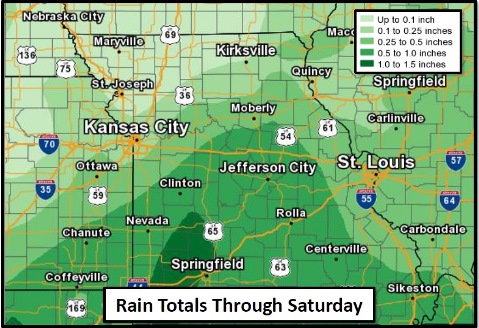
Rain is in the forecast for today and the weekend, according to the National Weather Service.
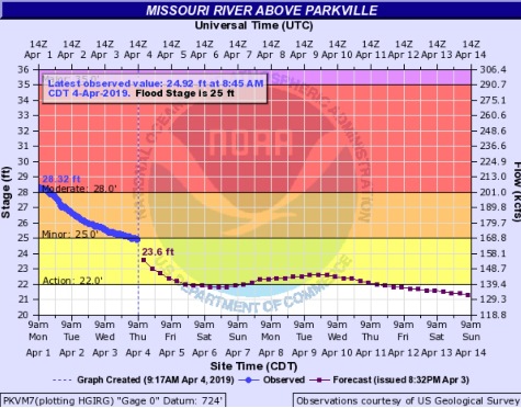
While there is still some Missouri River flooding along the river basin, the Missouri River at Parkville, which includes the Kansas City area, now has fallen below minor flood stage and into the action stage.
Leavenworth, Kansas, also has fallen below flood stage. Now in minor flood stage are St. Joseph, Missouri, and Atchison, Kansas.
River flooding is still possible, although flooding continues to recede through the area, according to the weather service. Water releases from the reservoirs to the north are being increased this week. The rainfall this week is not expected to have a significant effect on river flooding, the weather service said.
Today, residents will see showers with some isolated thunderstorms slowly moving east. Additional showers and thunderstorms are possible on Saturday, the weather service stated. No severe weather is expected.
Today, there is a 40 percent chance of showers, mainly before noon, the weather service said. The high will be near 59 with an east southeast wind of 5 to 7 mph, becoming northeast in the afternoon. Less than a tenth of an inch of rain is expected.
Tonight, there may be patchy fog after 1 a.m., with a low of 47. A northeast wind of 5 mph will become calm in the evening, according to the weather service.
Friday, patchy fog is possible before 9 a.m., with a high near 68, the weather service said. A calm wind will become south southeast 5 to 7 mph in the afternoon.
Friday night, the low will be around 51 with a southeast wind of around 7 mph, according to the weather service.
Saturday, there is a 40 percent chance of showers and thunderstorms after 1 p.m., the weather service said. The high will be near71 with a south southeast wind of 7 to 10 mph. Less than a tenth of an inch is possible.
Saturday night, there is a 70 percent chance of showers and possibly a thunderstorm before 1 a.m., followed by more showers and thunderstorms after 1 a.m., according to the weather service. The low will be around 56. Between a quarter and half-inch of rain is possible.
Sunday, it will be mostly cloudy with a high near 70, the weather service said.
Sunday night, it will be mostly cloudy, with a low of 50, according to the weather service.
Monday, it will be mostly sunny, with a high near 69, the weather service said.
Monday night, it will be mostly clear, with a low of 49, according to the weather service.
Tuesday, it will be mostly sunny, with a high near 70, the weather service said.
Tuesday night, it will be mostly cloudy, with a low of 53, according to the weather service.
Wednesday, there is 30 percent chance of showers, with a high near 69, the weather service said.