While the Missouri River near Wyandotte County has declined significantly in the past few days, rains, runoff and increased water releases from reservoirs to the north are expected to aggravate flooding in some areas.
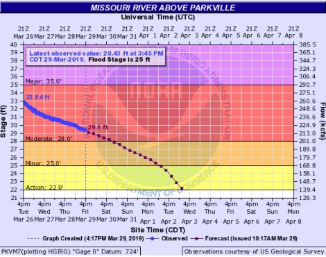
The Missouri River at Wyandotte County, which is covered by the Parkville gauge, remained in the moderate flood stage on Friday, March 29, as the river is currently projected to decrease to the minor flood stage on Saturday night, according to hydrology charts. The charts are subject to change. With the water receding here, the flood fight has shifted to central Missouri, although officials are monitoring towns all along the river for another rise on the weekend or Monday.
An Army Corps of Engineers, Missouri River Basin Water Management Division, official announced on Friday afternoon that they intend to increase water releases into the Missouri River from the current 36,000 cubic feet per second at the Gavins Point reservoir in South Dakota to 39,000 cfs on Sunday, to 42,000 cfs on April 3, then increasing it 2,000 to 4,000 cfs daily until it gets to 55,000 cfs. It usually takes around four to five days for water released at Gavins Point to reach Kansas City.
Corps officials stated that there are large inflows into the Missouri River basin system reservoirs from the remaining plains snowmelt in the upper basin. These large inflows were expected to continue during the next week. That results in a need for reservoirs to release more water, according to officials.
A National Weather Service forecaster said on Friday afternoon that with the rain, runoff and releases, some cities in Missouri will have two crests. Jefferson City, Missouri, crested on Thursday and is expected to crest again late Saturday night.
Herman, Missouri, is expected to have a second crest on Sunday, while St. Charles, Missouri, will crest for the second time late Sunday night.
In the Kansas City area, more rain is possible tonight, about a half-inch to three-quarters inch, and Saturday, as much as a tenth of an inch, then a frost is in the forecast for Saturday night, Sunday and Monday morning. The weather will warm up again on Monday. More rain is possible Wednesday night and Thursday, according to the forecast.