by Mary Rupert
Wyandotte County Emergency Management Director Matt May sees a possibility of the Missouri River in the Wyandotte County area rising again to about 30 feet by Monday or Tuesday.
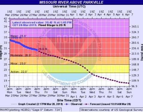
The river peaked at about 34.86 feet last weekend, and the level projected for the next rise is between four and five feet below that.
Both levels are in the moderate flooding level, where the Missouri River remains today. The river is receding, May said on Thursday, and is now to the point where K-5 and Wolcott Drive have reopened.
The river won’t be quite as high as last time, but it could be high enough to affect the areas that were affected last time, he said. If the Wolcott levee on the west side that broke isn’t fixed by then, the areas could flood again. He added the levee that broke was near the Wyandotte-Leavenworth county line, and most of it was probably in Leavenworth County, although water from it affected some Wyandotte County businesses.
The crest occurred in the early morning hours on Sunday.
“On Sunday morning, when I got there (on Wolcott Drive), I could have driven through it, it was maybe 6 to 8 inches in places,” May said. “I never tried it.”
Besides affecting traffic on Highway K-5, which is also Wolcott Drive in that area, the flooding also temporarily stopped traffic on a railroad line next to the highway. Railroad workers were trying to shore up the lines at that point, he said.
“It was certainly prudent to shut off the road,” he said.
The Nearman area also took on some flood water, May said.
Wyandotte County did not issue a flash flood warning on Sunday morning because they didn’t feel it would hit any residential areas, May said. A small number of businesses in the area were notified individually, he added.
Flood waters have already receded away from Wolcott Drive, and with the coming rains, the same area could get muddy again, he said.
On a positive note, a National Weather Service forecast originally called for 3 to 5 inches of rain here from Thursday to Saturday, but now calls for 1 to 2 inches, May said.
Rain upstream will probably affect flooding more than the local rains forecast over the next three days in the Kansas City area, according to May.
While the local rain has an effect and puts more stress on the local flooding, a much bigger effect is from rains up north in the Dakotas, he said. As rain falls there, it melts more of the snowpack, “like pouring water over an ice cube,” May said. It increases the water flowing into rivers that eventually go into the Missouri River.
“It’s not the rain here causing the problem, it’s the rain up north,” he said, adding that snow melting to the north also is a big factor. “If that forecast changes, all bets are off.”
There also is an effect from increased water releases from reservoirs upstream on the Missouri River. He would like more advance warning on how much water will be released.
“I know they’re probably holding back as much water as they can, probably giving us a chance to catch up,” he said.
The Gavins Point dam in South Dakota was releasing 33,000 cubic feet per second of water into the Missouri River on Wednesday, which was scheduled to increase to 36,000 cfs Thursday, then scheduled to be increased to 39,000 cfs on Sunday. May said the increase to 36,000 cfs was “pretty minimal” and he didn’t expect much of an effect from it in Kansas City.
May said no homes were reported to be affected by flooding in Wyandotte County. Most homes have been moved out of the lower-lying areas next to the Missouri River in Wyandotte County after previous floods.
Melissa Clark, executive director of the Fairfax Industrial Association, said that the Fairfax district, which includes many businesses and industries, is currently doing fine with the drainage district doing a good job. The industrial district is bordered on the north by the Missouri River.
“The (Fairfax) drainage district guys are working 24/7 to keep it up,” she said.
“They are on top of it and everything looks OK,” Clark said on Thursday. Water was being pumped out because of underseepage issues, she said. The system is performing well, she said.
The Fairfax Industrial Association has been posting updates from the Fairfax Drainage District on its webpage at https://fiakck.org/2019/03/23/update-flood-waters-on-the-rise-at-kaw-point-park/.
Kaw Point Park is in the Fairfax area on Fairfax Trafficway, at the confluence of the Missouri and Kansas rivers, and the statue of Lewis and Clark is often used as an informal measure by residents of how high the river is at that point. While the river rose chest-high on the statue last weekend, the water was still within the Fairfax levee.