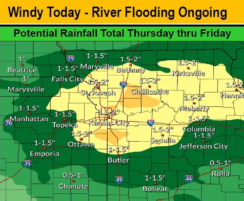
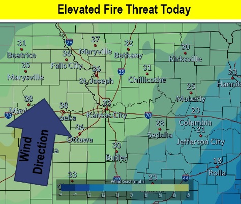
Today, temperatures may reach 70 degrees, with windy and dry weather causing an elevated fire danger, according to the National Weather Service forecast. On Thursday and Friday, heavy rain is expected in the region.
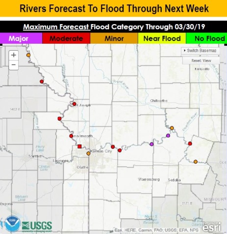
The heavy rains could aggravate the ongoing Missouri River flooding in the region, according to the weather service.
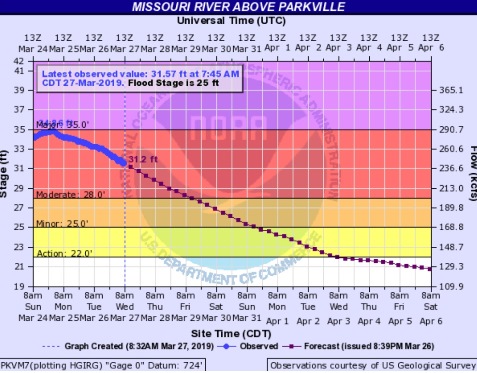
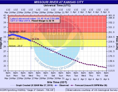
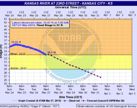
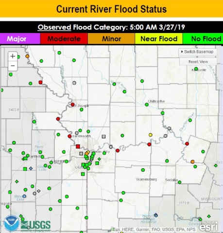
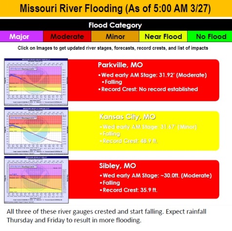
Currently, the Missouri River at Parkville, which includes the Wyandotte County region, is in moderate stage and the river level is falling, according to hydrology charts. The Missouri River at Kansas City, where the gauge is south of the downtown airport in Kansas City, Missouri, has now gone below minor flood stage. The Kansas River at 23rd Street, where the gauge is at Kansas Avenue and the state line, was still in minor flood stage at 7:45 a.m., but could go below minor flood stage sometime today.
Additional rain on Thursday and Friday, along with increased water releases from reservoirs upstream, may result in additional flooding on the weekend or early next week.
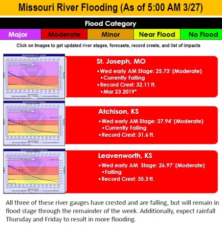
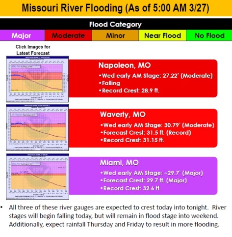
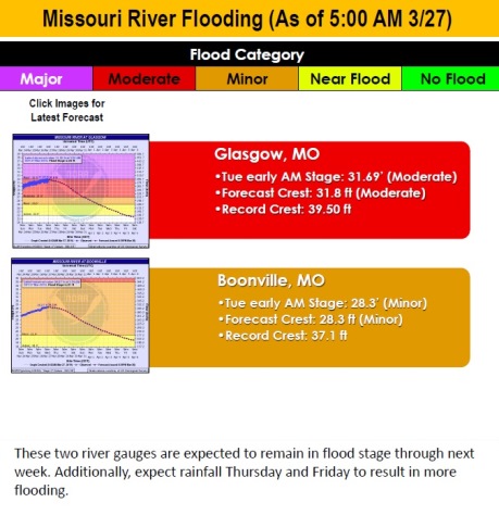
Leavenworth, Kansas, and St. Joseph, Missouri, are currently in moderate flood stage, according to hydrology charts.
This afternoon, gusty southerly winds will prevail, and coupled with moderately low after noon humidity values, below 40 percent, will result in an elevated fire threat for the region, the weather service said.
Today, the high may be near 71 with mostly sunny skies and a south wind of 9 to 14 mph, increasing to 16 to 21 mph in the afternoon, the weather service said. Winds may gust as high as 37 mph.
Tonight, it will be mostly cloudy, with a low of 55 and a south southwest wind of 10 to 14 mph, gusting as high as 24 mph, according to the weather service.
Thursday, there will be a 90 percent chance of showers and thunderstorms before 1 p.m., then showers and possibly a thunderstorm between 1 p.m. and 4 p.m., then showers after 4 p.m., the weather service said. The high will be near 66. A south southwest wind of 6 to 9 mph will become east southwest in the afternoon. Between a quarter and half-inch of rain is possible.
Thursday night, there is a 70 percent chance of showers before 1 a.m., then showers are likely and possibly a thunderstorm between 1 a.m. and 4 a.m., then showers and thunderstorms are likely after 4 a.m. The low will be around 51 with an east northeast wind around 7 mph. Between a quarter and half-inch of rain is possible.
Friday, there is a 90 percent chance of showers and possibly a thunderstorm before 1 p.m., then showers and thunderstorms after 1 p.m., the weather service said. The high will be near 60, with an east northeast wind of 7 mph becoming south southeast in the afternoon. Between a half-inch and three-quarters of an inch of rain is possible.
Friday night, there is an 80 percent chance of showers and thunderstorms, with a low of 37, according to the weather service. Between a quarter and half-inch of rain is possible.
Saturday, there is a 30 percent chance of showers before 1 p.m., with a high near 48, the weather service said.
Saturday night, it will be mostly clear with a low of 28, according to the weather service.
Sunday, it will be sunny with a high near 49, the weather service said.
Sunday night, it will be mostly clear, with a low of 33, according to the weather service.
Monday, it will be mostly sunny with a high near 57, the weather service said.
Monday night, it will be partly cloudy, with a low of 42, according to the weather service.
Tuesday, it will be partly sunny with a high near 65, the weather service said.