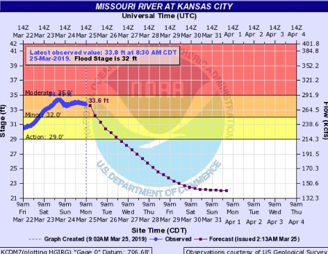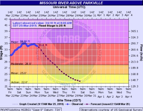
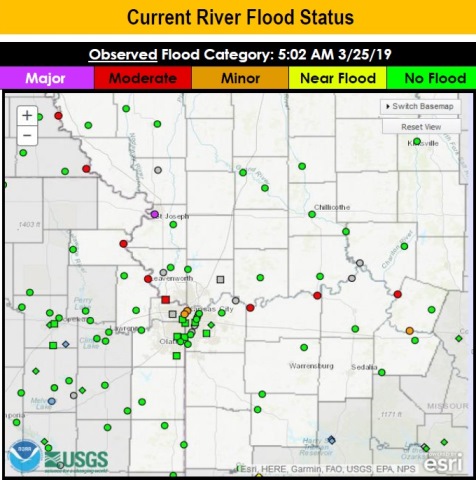
While the Missouri River remains high this morning at Wyandotte County, in moderate flood stage, it is still projected to decline over the next few days, leaving flood stage on Thursday, according to National Weather Service reports.
Besides the moderate and minor flood warning still in effect in Wyandotte County, the area has fog and mist this morning, and will see a high in the 50s, according to the weather service.
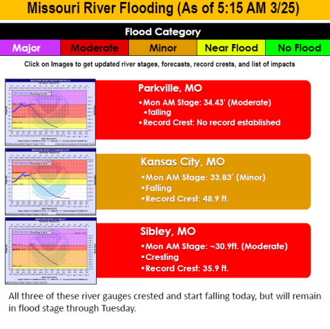
The Missouri River gauge at Parkville, which applies to Wyandotte County, showed small decreases and increases of inches on Sunday, and on Monday at 7:45 a.m. had a reading of less than a foot below the crest of Saturday night.
Wolcott Drive was still closed from flooding this morning at Hutton Road, near I-435 in western Kansas City, Kansas, according to KC Scout. Parts of Highway 9 on the Missouri side also were closed from flooding.
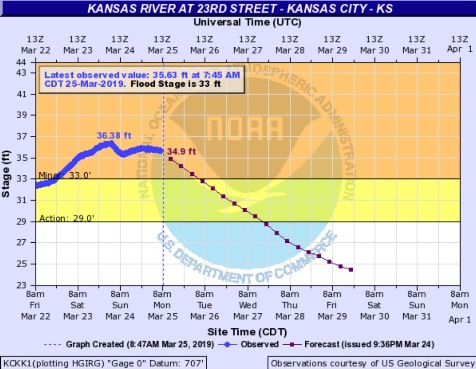
The river gauges at eastern Kansas City, Kansas, the Missouri River at Kansas City and the Kansas River at 23rd gauge, remain in minor flood stage, and are projected to decline out of flood stage on Tuesday and Wednesday.
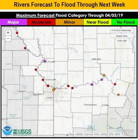
All of the projections could change depending on factors such as more water entering the river in the north from rain, snow melt and reservoir releases, and also upon levees that are overtopping or being repaired along the river .
Residents were advised by the weather service not to drive across flooded roads. As little as 6 inches of water in the road could be dangerous. Also, residents are advised not to be too close to levees, as residents could be at risk there.
The cool temperatures today, in the 50s, will warm up to the 70s by Wednesday, the weather service said.
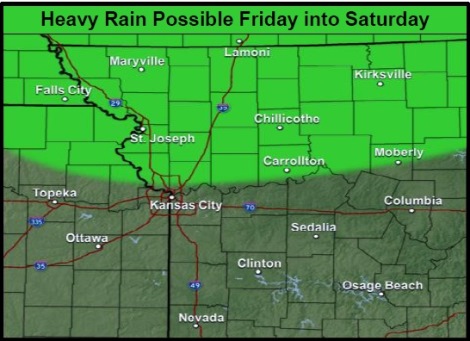
Heavy rain is possible over the northern part of the Kansas City region on Friday into Saturday, potentially aggravating current river flooding, the weather service said.
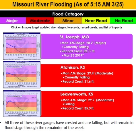
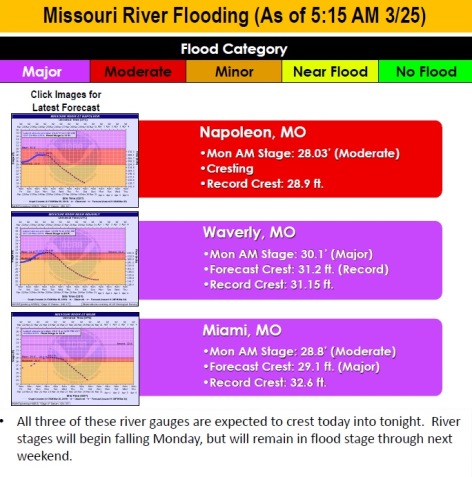
The Missouri River is at major flood stage currently in St. Joseph, Missouri. It also is in major flood stage at Waverly, Missouri, and Miami, Missouri, where it is cresting. The river is at moderate flood stage at Atchison and Leavenworth, Kansas, where it is falling, according to the weather service.
The Corps of Engineers announced on Sunday that it would increase the water released into the Missouri River from the Gavins Point dam in South Dakota today by 3,000 cubic feet per second, holding it at the 27,000 cfs level per day through March 31, when it may increase it to 30,000 cfs per day. That increased water flow may take five to six days to reach Kansas City.
Today, it will be mostly cloudy, with a high near 54 and a north northeast wind of 8 to 11 mph, the weather service said.
Tonight, the low will be around 38, with a north northeast wind of 3 to 6 mph, according to the weather service.
Tuesday, it will be mostly sunny with a high near 59 and a southeast wind of 5 mph, the weather service said.
Tuesday night, the low will be around 43 with a south southeast wind of 6 to 8 mph, according to the weather service.
Wednesday, it will be mostly sunny with a high near 70 and a south wind of 9 to 18 mph, gusting as high as 26 mph, the weather service said.
Wednesday night, there is a 30 percent chance of showers, and a chance of showers and thunderstorms after 1 a.m., according to the weather service. The low will be around 54. Less than a tenth of an inch of rain is possible, except there may be higher amounts in thunderstorms.
Thursday, there is a 60 percent chance of showers and thunderstorms, then showers likely after 1 p.m., the weather service said. The high will be near 68.
Thursday night, there is a 60 percent chance of showers and thunderstorms, followed by showers after 1 a.m., according to the weather service. The low will be around 54.
Friday, there is an 80 percent chance of showers and thunderstorms, with a high near 64, the weather service said.
Friday night, there is an 80 percent chance of showers and a thunderstorm before 1 a.m., then showers are likely, according to the weather service. The low will be around 40.
Saturday, there is a 70 percent chance of showers, with a high near 47, the weather service said.
Saturday night, the low will be around 32 with partly cloudy skies, according to the weather service.
Sunday, it will be sunny with a high near 51, the weather service said.