Water releases from reservoirs to the north have been reduced, but Kansas City remains in the path of minor flooding on the Missouri River, currently projected for Thursday.
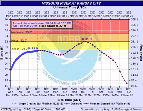
Today’s projections from hydrology charts from the National Weather Service show the Missouri River at Kansas City going into an action stage on Tuesday, then rising to a point just a little bit into minor flood stage on Thursday. (See https://water.weather.gov/ahps2/hydrograph.php?wfo=eax&gage=kcdm7)
The hydrology charts change each day depending on the circumstances. For example, some factors that would change these flood predictions include levees that fail upstream from Kansas City, reducing the water flow; and any additional rainfall or runoff along the river that increases the water flow.
Water releases into the Kansas River have been reduced this week at Tuttle Creek in the Manhattan, Kansas, area, which is preventing the Kansas City area from flooding as much. (See https://www.nwk.usace.army.mil/Media/News-Releases/Article/1786933/tuttle-creek-lake-officials-expecting-continued-lake-level-rise/) Other releases along the Kansas River also have been reduced.
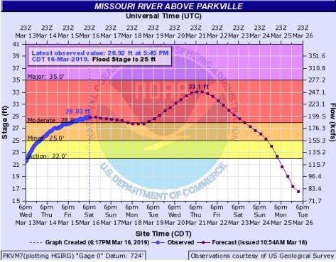
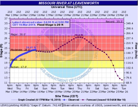
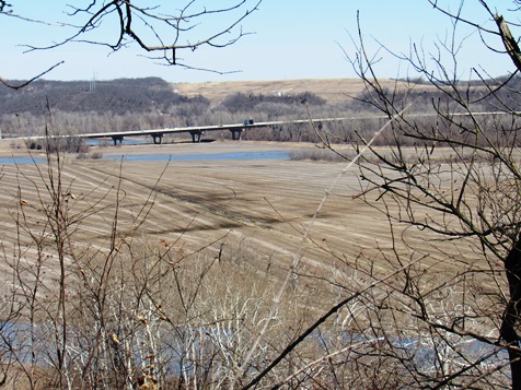
Many cities along the Missouri River upstream are currently flooding, including Leavenworth, Kansas, Atchison, Kansas, St. Joseph, Missouri, and Parkville, Missouri. Some cities to the north of Kansas and Missouri are experiencing major flooding. (See https://water.weather.gov/ahps2/index.php?wfo=eax)
Corps of Engineers officials said they had increased the water releases on Thursday into the Missouri River at Gavins Point in South Dakota to over 90,000 cubic feet per second after runoff from uncontrolled tributaries, including the Niobara River. Gavins Point has a relatively small amount of flood control storage and did not have the capacity to handle the runoff, according to officials.
After the recent increase in water releases, the Corps of Engineers on Friday evening reduced the water releases from 90,000 to 80,000 cfs, according to officials. This morning, they reduced releases to 73,000 cfs, and at 6 p.m. this evening, they reduced it to 63,000 cfs.
Currently, major river flooding is occurring from Nebraska City through St. Joseph, Missouri, according to a National Weather Service official. Minor flooding is occurring from Gavins Point through Omaha. Minor flooding also is occurring from St. Joseph to Kansas City. The river is expected to crest in Sioux City on Sunday, and the river will crest in Kansas City by Thursday of next week.
Officials said at a Corps of Engineers news conference Saturday they did not think the quarter-inch to half-inch of precipitation expected in Kansas City on Wednesday and Thursday would affect the flooding.
Several levees already have overtopped upstream, including some south of Omaha, according to officials, which also affects the water flowing to the Kansas City area. Hamburg, Iowa, is one place where evacuations are taking place. Other levee breaches include near Rulo, Nebraska; near Plattsmouth, Nebraska; near Brownville, Nebraska; and near Valley Nebraska. The Corps of Engineers described an “extensive overflowing of the levees systems” on the Missouri River, with numerous breaches. (See https://www.nwo.usace.army.mil/Media/News-Releases/Article/1787216/omaha-corps-of-engineers-working-shoulder-to-shoulder-with-state-local-tribal-a/)
Closer to the Kansas City area, the Corps of Engineers is focusing on Holt and Buchanan counties in Missouri, Doniphan County in Kansas and Richardson County in Nebraska. Two levees have overtopped in Holt County, Missouri, according to Corps of Engineers officials. About nine nonfederal program levee systems are performing as designed, but are considered at risk by the Corps of Engineers.
Parkville, Missouri, which is across the river from Kansas City, Kansas, is currently in moderate flood stage.
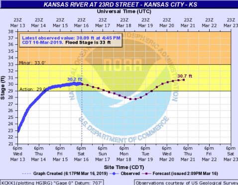
The National Weather Service has listed the Wolcott levees in northwestern Wyandotte County as at risk of being overtopped at 32 and 32.5 feet. The Missouri River is projected to reach 33 feet on Thursday. (See https://forecast.weather.gov/showsigwx.php?warnzone=KSZ104&warncounty=KSC209&firewxzone=KSZ104&local_place1=4%20Miles%20NE%20Edwardsville%20KS&product1=Hazardous+Weather+Outlook&lat=39.1149&lon=-94.7708#.XI2a0SJKiUk)
Corps of Engineers officials said they have an inventory of 4 million sandbags currently for this district.
One official said that the main difference between this year’s flood and the floods of 1993 and 2011 is that a large portion of the flows they are dealing with are unregulated flows, some involving tributaries that flow into the Missouri River. There is also rain and melting snow.
The snowpack upstream has been about average, and there is still considerable snow in South Dakota that will be melting and going into the river south of Gavins Point dam, according to officials.
To see Missouri River releases, flows and stages, visit http://www.nwd-mr.usace.army.mil/rcc/reports/pdfs/GRFT.pdf.