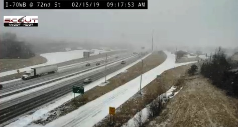

Light snow was falling at 9 a.m. in Wyandotte County, and a winter weather advisory is in effect through 9 p.m. Friday, according to the National Weather Service.
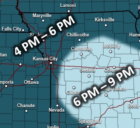
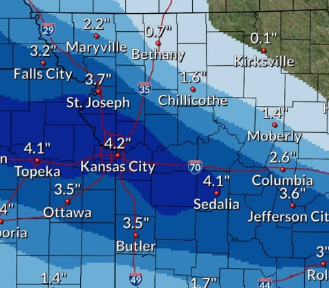
Three to 5 inches of snow is possible today. Moderate to occasional heavy snow is expected through 10 a.m. today, and also from 6 to 9 p.m., according to the weather service forecast. Snow is possible throughout the day, and the heaviest snowfall could be between 9 a.m. and 3 p.m.
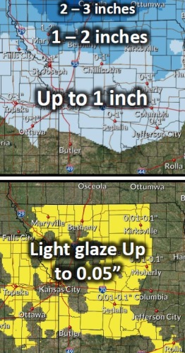
Saturday also has a forecast of snow with a winter weather advisory in effect from 7 a.m. to 9 p.m. Saturday. Around 1 inch of snow is possible on Saturday, probably after noon.
Today, the high will be near 19, with a 100 percent chance of snow showers, the weather service said. A north northeast wind will be 8 to 10 mph. Total daytime snow accumulation of 3 to 5 inches of snow is possible.
Tonight, there is a 30 percent chance of snow showers, mainly before 7 p.m., with a low of 11 and a northeast wind of 5 to 9 mph, according to the weather service.
Saturday, there is a 30 percent chance of snow after noon, the weather service said. The high will be near 28 with an east wind of 5 to 10 mph.
Saturday night, there is a 70 percent chance of precipitation, with snow likely before 7 p.m., then snow and freezing rain likely, according to the weather service. The low will be around 21 with an east wind of 5 to 8 mph becoming west northwest after midnight. Little or no ice accumulation is expected. New snow accumulation could be less than a half-inch possible.
Sunday, it will be partly sunny with a high near 31, the weather service said. A west northwest wind of 6 to 11 mph will gust as high as 21 mph.
Sunday night, it will be mostly cloudy with a low of 16, according to the weather service.
Monday, Presidents Day, it will be mostly cloudy with a high near 28, the weather service said.
Monday night, it will be mostly cloudy with a low of 17, according to the weather service.
Tuesday, there is a 30 percent chance of snow after noon, the weather service said, with a high near 30.
Tuesday night, there is an 80 percent chance of snow, with a low of 22, according to the weather service.
Wednesday, it will be mostly cloudy with a high near 33, the weather service said.
Wednesday night, it will be partly cloudy, with a low of 17, according to the weather service.
Thursday, it will be mostly sunny with a high near 36, the weather service said.