Wyandotte County is under an ice storm warning now through noon Thursday, according to the National Weather Service.
Periods of light freezing rain and drizzle are expected in the area now through Thursday morning.
The heaviest period of freezing rain is expected to occur this evening and overnight, the weather service said.
Hazardous road conditions have developed, especially on bridges, overpasses and any untreated surfaces.
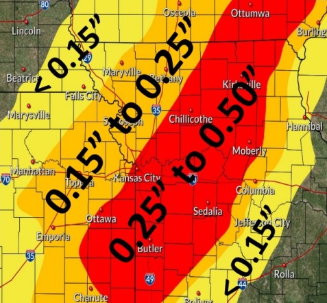
Additional ice accumulations between .25 inch to .5 inch are possible, according to the weather service.
Strong winds from the northwest on Thursday could cause tree and power line issues even after the precipitation ends, the weather service said.
The weather service stated that travel is strongly discouraged during an ice storm. Those who travel should keep an extra flashlight, food and water in their vehicle, in case of emergency. Snapped power lines and falling tree branches are possible.
Tonight, freezing rain is possible, and could be mixed with sleet before 2 a.m., then freezing rain between 2 a.m. and 4 a.m., then freezing rain likely, mixed with sleet after 4 a.m., according to the weather service.
The low tonight will be around 17 with a north wind of 7 to 15 mph, gusting as high as 21 mph, according to the weather service. From one-tenth to three-tenths of an inch of new ice accumulation is possible.
On Thursday, there will be a 50 percent chance of snow, freezing drizzle and sleet before 9 a.m., then a chance of snow and sleet between 9 a.m. and noon, the weather service said. The high will be near 18 with wind chill values of between minus 3 and 6. The west northwest wind will be 16 to 23 mph, gusting as high as 32 mph. Less than a tenth of an inch of new precipitation is likely.
For weather updates, visit www.weather.gov.