Wyandotte County will be under a winter weather advisory from noon Tuesday through noon Wednesday, with light freezing rain and drizzle expected.
Patchy light freezing rain and drizzle could overspread the area beginning late this morning into the afternoon, the National Weather Service said.
Periodic light precipitation will continue tonight into Wednesday, the weather service said. These periods of precipitation may be short-lived, but motorists need to be careful.
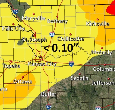
Where temperatures remain below freezing, minor ice accumulations of one-tenth of an inch or less are possible, according to the weather service.
Hazardous road conditions may develop, especially on bridges and overpasses, the weather service said. This potentially includes this evening and Wednesday morning commutes.
The weather service urged motorists to slow down and be careful when driving. More winter weather is in the forecast for Thursday, also.
The temperature was 25 degrees with a wind chill of 14 at 9 a.m. Tuesday, Feb. 5.
Today, there is a 20 percent chance of freezing drizzle and sleet before 10 a.m., then a chance of freezing drizzle, the weather service said. The high will be near 31, with an east northeast wind of 6 to 9 mph.
Tonight, there is a chance of freezing drizzle before midnight, then a slight chance of freezing drizzle after 2 a.m., according to the weather service. The low will be around 28 with a north wind of 6 to 8 mph.
Wednesday, there is a 40 percent chance of freezing drizzle before noon, then a chance of rain, the weather service said. It will be mostly cloudy, with a high near 39. There will be a north northeast wind of around 8 mph, with less than a tenth of an inch of precipitation possible.
Wednesday night, there will be a 50 percent chance of rain or freezing rain before 4 a.m., then a chance of freezing rain and sleet between 4 a.m. and 5 a.m., then a chance of snow and sleet after 5 a.m., according to the weather service. The low will be around 21. A north northeast wind of 6 to 13 mph will become northwest after midnight. Less than a tenth of an inch of precipitation is possible.
Thursday, there will be a 30 percent chance of snow before noon. The high will be near 22, with a northwest wind of 13 to 17 mph, gusting as high as 25, the weather service said.
Thursday night, it will be mostly clear with a low around 7, according to the weather service.
Friday, it will be sunny with a high near 24, the weather service said.
Friday night, it will be clear, with a low of 12, according to the weather service.
Saturday, it will be sunny, with a high near 39, the weather service said.
Saturday night, there is a 30 percent chance of snow after midnight. The low will be 26, according to the weather service.
Sunday, there is a 30 percent chance of rain and snow, with a high near 40, the weather service said.
Sunday night, it will be mostly cloudy, with a low of 26, according to the weather service.
Monday, there is a 30 percent chance of rain, with a high near 40, the weather service said.
For more weather information, visit www.weather.gov.