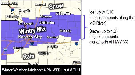
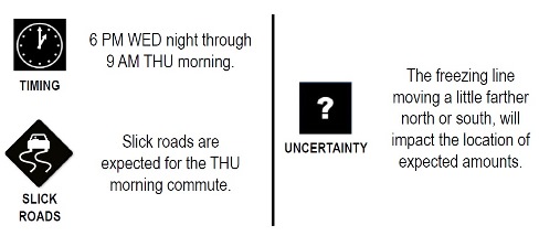
Wyandotte County is under a winter weather advisory for 6 p.m. Wednesday through 9 a.m. Thursday, according to the National Weather Service.
A mix of ice and snow is possible this evening in Wyandotte County.
Freezing drizzle and light freezing rain are expected by this evening, into tonight, within a swath from along the Interstate 70 corridor in Wyandotte County northward to Highway 36, near St. Joseph, Missouri, the weather service said.
A glazing of ice on surfaces and roadways will be possible in these areas, according to the weather service. Light snow will occur north of the ice swath.
Dense fog and patchy freezing drizzle are possible through noon today in the region, along and south of the Missouri River, the weather service said. This may create a few slick spots.
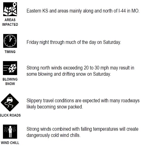
After the Wednesday night and Thursday ice event, the next chance for accumulating snowfall will be Friday night into Saturday, according to the weather service. Uncertainty remains as to the details of this weekend storm.
Dangerously cold temperatures are expected this weekend as well, with temperatures going into the single digits and wind chills well below zero, the weather service said.
Today’s forecast is widespread dense freezing fog, mainly before 11 a.m., with a high today near 32 and an east wind around 6 mph, the weather service said. There is a slight chance of freezing drizzle after 1 p.m., with patchy dense fog possible after noon.
Tonight, there is a 50 percent chance of freezing rain and sleet before 10 p.m., then a chance of sleet between 10 p.m. and 11 p.m., followed by a chance of freezing rain and sleet after 11 p.m., according to the weather service. Patchy fog is possible before 5 a.m. The low will be around 30 with an east northeast wind of 6 mph. Less than a tenth of an inch of precipitation is possible.
Thursday, there is a 50percent chance of freezing rain and sleet before 7 a.m., with a high near 36, the weather service said. A north northeast wind of 6 mph will become northwest in the afternoon. Less than a tenth of an inch of precipitation is possible.
Thursday night, it will be mostly cloudy with a low of 26 and a northwest wind of 5 mph, becoming calm, according to the weather service.
Friday, there is a 30 percent chance of snow before 2 p.m., then rain and snow between 2 p.m. and 3 p.m., then a chance of rain after 3 p.m., the weather service said. The high will be near 38, with an east southeast wind of 5 to 10 mph. New precipitation of less than a tenth of an inch is possible.
Friday night, there is a 90 percent chance of rain before 9 p.m., then rain and snow between 9 p.m. and midnight, and snow after midnight, according to the weather service. The low will be around 23. Between a quarter and half-inch of precipitation is possible.
Saturday, there is a 90 percent chance of snow, mainly before 1 p.m., with a high near 23, the weather service said. It will be blustery.
On Saturday night, there is a 40 percent chance of snow before 7 p.m., with a low of around 4, according to the weather service.
Sunday, expect mostly sunny skies and a high near 18, the weather service said.
Sunday night, it will be partly cloudy, with a low of 12, according to the weather service.
On Monday, the Martin Luther King Jr. holiday, it will be mostly sunny with a high near 35, the weather service said.
Monday night, there is a 30 percent chance of snow and freezing rain, with a low around 24, according to the weather service.
Tuesday, there is a 40 percent chance of snow, with a high near 31, the weather service said.
Visit www.weather.gov for the latest weather updates and changes in the forecast.
Friday night to Saturday winter storm potential: