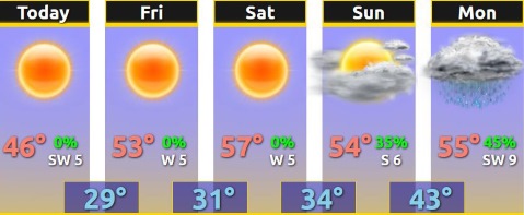
Today’s high will be near 46, and clear weather is expected for the next week, according to the National Weather Service.
The next chance for widespread precipitation will arrive late Sunday night through Monday, the weather service said. Currently, only rain is expected.
The region, including Wyandotte County, is predicted to have higher than normal temperatures during the second and third weeks of January, according to the weather service.
Today, it will be sunny with a high near 46 and a southwest wind of 3 to 7 mph, the weather service said.
Tonight, the low will be around 27 with clear skies and a west southwest wind of 3 to 5 mph, according to the weather service.
Friday, it will be sunny with a high near 53 and a west wind of 3 to 6 mph, the weather service said.
Friday night, it will be clear with a low of 30 and a west wind of 3 to 5 mph, according to the weather service.
Saturday, it will be sunny with a high near 57 and a southwest wind of 3 to 7 mph, the weather service said.
Saturday night, it will be mostly clear with a low of 36, according to the weather service.
Sunday, it will be partly sunny with a high near 55, the weather service said.
Sunday night, there is a 40 percent chance of rain after midnight, with a low of 43, according to the weather service.
Monday, there is a 30 percent chance of rain before noon, with a high near 55, the weather service said.
Monday night, it will be partly cloudy with a low of 33, according to the weather service.
Tuesday, it will be sunny with a high near 52, the weather service said.
Tuesday night, it will be mostly clear with a low of 31, according to the weather service.
Wednesday, it will be sunny with a high near 50, the weather service said.