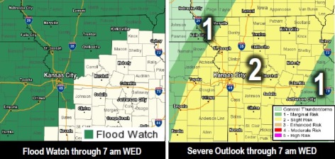
As a flood warning continues in Wyandotte County through 4 p.m. Tuesday, there also is the possibility of strong to severe storms.
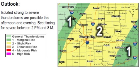
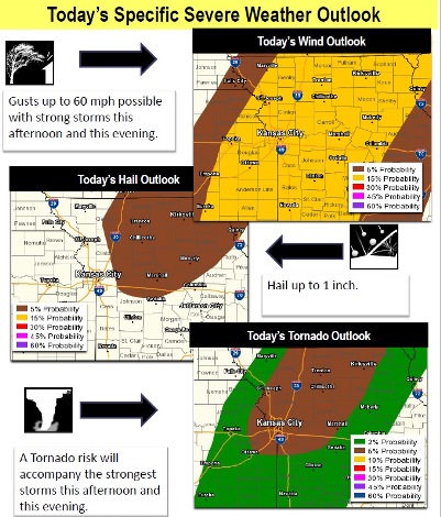
Strong to severe storms are possible this afternoon and evening, with damaging winds and isolated tornadoes the primary threats, the weather service said.
Primary time for the wind and tornado threat will be from 2 p.m. through 8 p.m. today, according to the weather service.
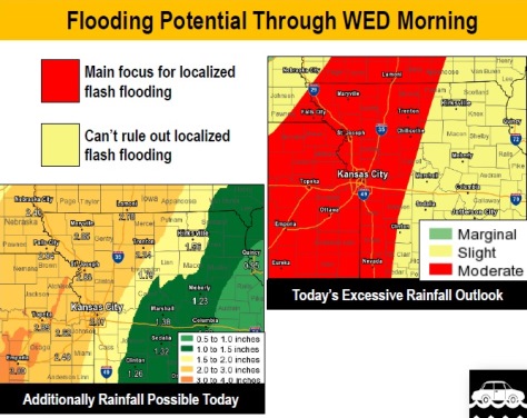
Widespread excessive rainfall has already begun to impact the region, and will continue through the day into the overnight hours as another widespread 1 to 3 inches of rain is expected across eastern Kansas and northwest Missouri through Wednesday morning, the weather service said.
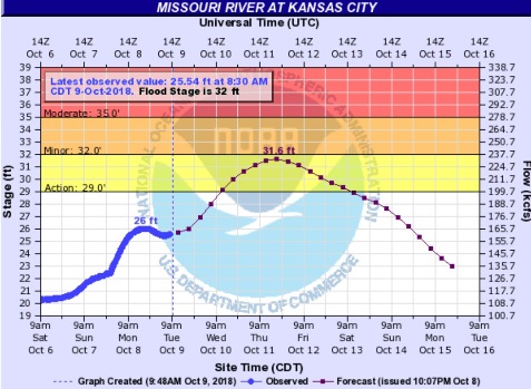
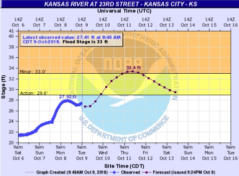
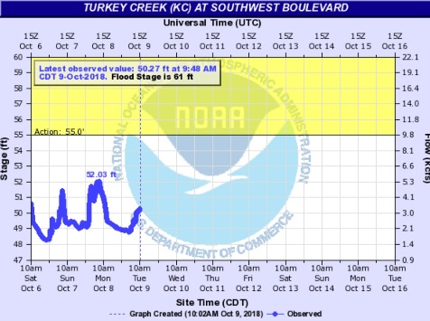
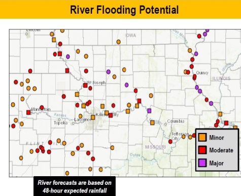
The cumulative effect of the multiple rounds of rain has already resulted in minor to major river flooding, flash flooding, and general area flooding; and today’s storms will only exacerbate all these flooding issues, according to the weather service.
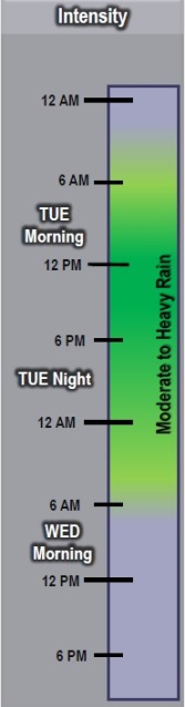
Waves of moderate to heavy rain showers will persist this morning across the Kansas-Missouri state line, the weather service said.
Storms that develop in the afternoon will spread east and northeast through the afternoon and evening hours, according to the weather service.
On-and-off storms are expected this morning, with strong to severe storms expected this afternoon and evening, the weather service said. The most likely time for storms is between 2 p.m. and 8 p.m. today.
Increasing storm chances are expected through the afternoon, beginning across the Kansas and Missouri state line, before gradually pushing east early this evening, according to the weather service.
Widespread rain will likely persist late tonight through Wednesday morning, the weather service said.
There is high confidence in storm chances across the area today, according to the weather service, and high confidence in minor to major river and area flooding continuing.
There is also high confidence for localized flash flooding developing with the strongest storms, the weather service said.
There is moderate confidence for severe weather today, with the focus on the wind threat; but tornadoes cannot be ruled out, according to the weather service.
The focus for flooding concerns remains on areas along the Kansas-Missouri state line and northwest Missouri today and tonight where a lot of rain has already fallen, the weather service said.
Localized flash flooding concerns will spread east tonight, along with the storms; though with areas of central to northeast Missouri not getting as much rain in the past 48 hours, the risk looks lower, according to the weather service.
A flood watch will continue in Wyandotte County through 7 a.m. Wednesday, the weather service said.
Today’s forecast is a 90 percent chance of showers and storms, with some storms severe, with heavy rain, the weather service said. Patchy fog is possible between 3 p.m. and 4 p.m. The high today will be near 74 with a south southeast wind of 6 to 11 mph, gusting as high as 21 mph. Between a half and three-quarters of an inch of rain are possible.
Tonight, there is an 80 percent chance of showers and thunderstorms before 3 a.m., then showers are likely and possibly a thunderstorm between 3 a.m. and 5 a.m., followed by showers and thunderstorms after 5 a.m., according to the weather service. Some of the storms could produce heavy rain. The low will be around 51 with a south wind of 11 mph becoming west southwest after midnight. Between a half and three-quarters of an inch of rain are possible.
Wednesday, there is a 30 percent chance of showers before 7 a.m., with cloudy skies changing to mostly sunny, and a high near 59, the weather service said. A west wind of 10 to 13 mph will gust as high as 21 mph. Less than a tenth of an inch of rain is possible.
Wednesday night, it will be mostly clear with a low of 39 and a northwest wind of 9 mph, according to the weather service.
Thursday, expect sunny skies with a high near 57 and a northwest wind of 7 to 10 mph, the weather service said.
Thursday night, it will be partly cloudy with a low of 41, according to the weather service.
Friday, there is a 40 percent chance of precipitation with a high near 54, the weather service said.
Friday night, it will be mostly cloudy with a low of 43, according to the weather service.
Saturday, there is a 70 percent chance of showers, mainly after 1 p.m., with a high near 57, the weather service said.
Saturday night, there is a 100 percent chance of showers with a low of 45, according to the weather service.
Sunday, there is a 50 percent chance of showers with a high near 50, the weather service said.
Sunday night, there is a 30 percent chance of showers with a low of 36, according to the weather service.
Monday, the high will be near 51 with mostly sunny skies, the weather service said.
Residents should monitor weather reports today on broadcast media, on the weather service’s website at www.weather.gov, and on weather radios.