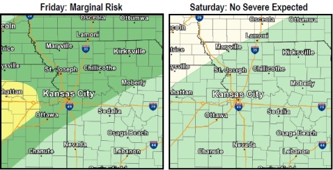
Storms are possible this evening, after 4 p.m. through early Saturday afternoon, according to the National Weather Service.
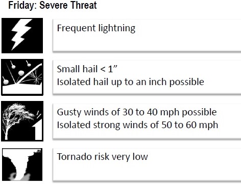
Isolated hail and damaging winds are possible in the strongest storms through the late evening hours, the weather service said.
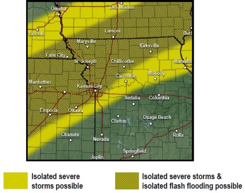
Isolated flash flooding is possible in the Kansas City area this evening through early Saturday afternoon, according to the weather service.
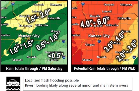
Moderate to heavy rain is likely this evening through early Saturday afternoon, and may lead to localized flash flooding, the weather service said.
There is a potential for total rainfall of more than 6 inches across much of the region, through the middle of next week according to the weather service.
The cumulative effect of the rounds of rain may lead to river flooding from the later half of this week into next week, the weather service said. There is rain in the forecast every day through Wednesday.
Today, there is a 30 percent chance of showers and thunderstorms, with a high near 82, the weather service said. A light south wind will increase to 5 to 9 mph in the morning. Less than a tenth of an inch of rain is expected.
Tonight, there is a 90 percent chance of showers and thunderstorms, according to the weather service. The low will be around 57. A south wind of around 9 mph will become north northwest after midnight. Between a half and three-quarters of an inch of rain is possible.
Saturday, there is a 90 percent chance of showers and possibly a thunderstorm, the weather service said. Patchy fog is possible between 10 a.m. and 11 a.m., and the day’s high will be near 61, with a north wind of 7 to 9 mph. Between a half and three-quarters of an inch of rain is possible.
Saturday night, there is a 90 percent chance of showers and possibly a thunderstorm, with a low of 55, according to the weather service, with a northeast wind of 6 to 8 mph. Between a half and three-quarters of an inch of rain is possible.
Sunday, there is a 90 percent chance of showers and possibly a thunderstorm, with a high near 71, the weather service said. An east northeast wind around 6 mph will become southeast in the afternoon. Between three-quarters and 1 inch of rain is possible.
Sunday night, there is an 80 percent chance of showers and a thunderstorm, with a low of 66, according to the weather service. Between three-quarters and 1 inch of rain is possible.
On Monday, Columbus Day, there is a 60 percent chance of showers, then possibly a thunderstorm after 1 p.m., with a high near 79, the weather service said.
On Monday night, there is a 40 percent chance of showers and thunderstorms, with a low of 67, according to the weather service.
Tuesday, there is a 70 percent chance of showers with a high near 76, the weather service said.
Tuesday night, there is a 70 percent chance of showers, mainly before 1 a.m., with a low of 54, according to the weather service.
Wednesday, there is a 30 percent chance of showers with a high near 67, the weather service said.
Wednesday night, it will be mostly clear with a low of 48, according to the weather service.
Thursday, it will be sunny with a high near 64, the weather service said.