Flash flooding possible later in week
Today will be very breezy, according to the National Weather Service, with a south southwest wind of 14 to 24 mph gusting as high as 39 mph.
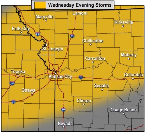
Isolated strong storms are possible Wednesday evening in some areas of the region. Hail and damaging winds are possible in the strongest storms, the weather service said.
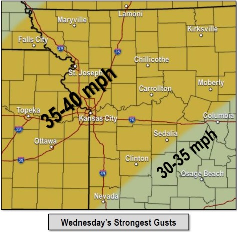
Strong and gusty winds of 30 to 40 mph are expected through the day Wednesday, according to the weather service.
Elevated fire danger is possible Wednesday afternoon because of high winds, the weather service said.
Multiple rounds of rain are expected from this evening through the weekend and into next week, according to the weather service. This could lead to localized flash flooding Thursday and Friday.
Through the middle of next week, there is the possibility of widespread rains of more than 6 inches total across much of the outlook area, the weather service said. Heavy rain is in the forecast for Friday night.
The cumulative effect of the rounds of rain could lead to river flooding from the later half of this week through next week, according to the weather service.
Today, the high will be near 88, with a south southwest wind of 14 to 24 mph, gusting as high as 39 mph, the weather service said.
Tonight, there is an 80 percent chance of precipitation, with a low of 60, according to the weather service. A south southwest wind of 9 to 14 mph will become north northeast after midnight. Winds may gust as high as 21 mph. Between a quarter and half-inch of rain is expected.
Thursday, there is a 50 percent chance of showers and thunderstorms, with a high near 62, and a north northeast wind of 9 to 13 mph. Less than a tenth of an inch of rain is expected.
Thursday night, there is a 50 percent chance of showers and thunderstorms, with a low of 57, according to the weather service. An east wind of 5 to 10 mph will become south southeast after midnight. Between a tenth and quarter-inch of rain is possible.
Friday, there is a 40 percent chance of showers and thunderstorms, with a high near 83, the weather service said. A south southwest wind of 7 to 13 mph will gust as high as 20 mph. Less than a tenth of an inch of rain is expected.
Friday night, there is a 90 percent chance of showers and thunderstorms, with a low of 59, according to the weather service. Between three-quarters and 1 inch of rain is possible.
Saturday, there is an 80 percent chance of showers and thunderstorms, mainly before 1 p.m., the weather service said. The high will be near 64.
Saturday night, there is a 90 percent chance of showers and thunderstorms, mainly after 1 a.m., according to the weather service. The low will be around 55.
Sunday, there is a 90 percent chance of showers and thunderstorms, with a high near 71, the weather service said.
Sunday night, there is a 70 percent chance of showers and thunderstorms, mainly before 1 a.m., according to the weather service. The low will be around 65.
On Monday, Columbus Day, there is a 70 percent chance of showers and thunderstorms, with a high near 78, the weather service said.
Monday night, there is an 80 percent chance of showers and thunderstorms, with a low of 60, according to the weather service.
Tuesday, there is a 60 percent chance of showers and thunderstorms, with a high near 70, the weather service said.