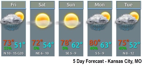
A cool front has moved through the area with overnight rain, and it will bring a high of 72 today, according to the National Weather Service.
Rain is expected to end by midmorning Friday in the Kansas City area, and then dry conditions will return and persist through the weekend, the weather service said.
Friday and Saturday highs will peak in the low 70s, with slightly warmer temperatures on Sunday, according to the weather service.
Scattered rain showers and storms are in the forecast for late Monday through late Tuesday.
Today, the high will be near 72 with partly sunny skies, the weather service said. A north wind of 9 to 14 mph will gust as high as 20 mph.
Tonight, it will be partly cloudy with a low of 51, and a northeast wind of 7 to 10 mph, according to the weather service.
Saturday, it will be sunny with a high of 72 and an east northeast wind of 7 mph, the weather service said.
Saturday night, it will be clear with a low of 54 and an east wind of 3 to 5 mph, according to the weather service.
Sunday, the high will be near 79 with sunny skies and a southeast wind of 3 to 7 mph, the weather service said.
Sunday night, it will be partly cloudy with a low of 61, according to the weather service.
Monday, there is a 30 percent chance of showers after 1 p.m., with a high near 80, the weather service said.
Monday night, there is a 40 percent chance of showers with a low of 63, according to the weather service.
Tuesday, there is a 40 percent chance of showers with a high near 74, the weather service said.
Tuesday night, it will be partly cloudy with a low of 53, according to the weather service.
Wednesday, it will be mostly sunny with a high near 71, the weather service said.
Wednesday night, it will be partly cloudy with a low of 54, according to the weather service.
Thursday, it will most mostly sunny with a high near 72, the weather service said.