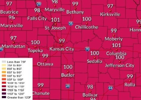
Highs for the next two days will be in the upper 80s to mid 90s, according to the National Weather Service, with a cold front moving in Thursday evening.
Wednesday will be the hottest day, with the eat index approaching the lower 100-degree range, the weather service said.
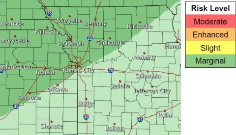
There is a chance of showers and thunderstorms south of the Kansas City area tonight, according to the weather service.
A cold front moving into the region from the northwest on Thursday evening will result in thunderstorm chances overnight into early Friday, the weather service said.
Temperatures will drop into the 70s Friday through Sunday, behind the front, according to the weather service.
Today, skies will be mostly sunny with a high near 94 and heat index values as high as 99, the weather service said. A south southwest wind of 6 to 15 mph will gust as high as 20 mph.
Tonight, it will be mostly clear with a low of 74, and a south wind of 8 to 10 mph, according to the weather service.
Thursday, it will be sunny with a high near 91 and heat index values as high as 95, the weather service said. A south southwest wind of 9 to 14 mph will increase to 15 to 20 mph in the afternoon, gusting as high as 36 mph.
Thursday night, there is a 60 percent chance of showers and thunderstorms before 1 a.m., then shows likely and possibly a storm between 1 a.m. and 4 a.m., then showers and thunderstorms likely after 4 a.m., according to the weather service. The low will be around 67 with a south wind of 7 to 15 mph becoming west northwest after midnight, and winds gusting up to 24 mph. Between a tenth and quarter-inch of rain is possible.
Friday, there is a 60 percent chance of showers and thunderstorms, mainly before 7 a.m., the weather service said. The high will be near 72 with a north wind of 7 to 11 mph. Less than a tenth of an inch of rain is expected.
Friday night, it will be partly cloudy with a low of 53, according to the weather service.
Saturday, it will be mostly sunny with a high near 72, the weather service said.
Saturday night, the low will be around 57, with partly cloudy skies, according to the weather service.
Sunday, expect mostly sunny skies and a high near 78, the weather service said.
Sunday night, the low will be around 63 with partly cloudy skies, according to the weather service.
Monday, there is a 30 percent chance of showers with a high near 77, the weather service said.
Monday night, there is a 40 percent chance of showers and thunderstorms, with a low of 63, according to the weather service.
Tuesday, there is a 40 percent chance of showers with a high near 72, the weather service said.