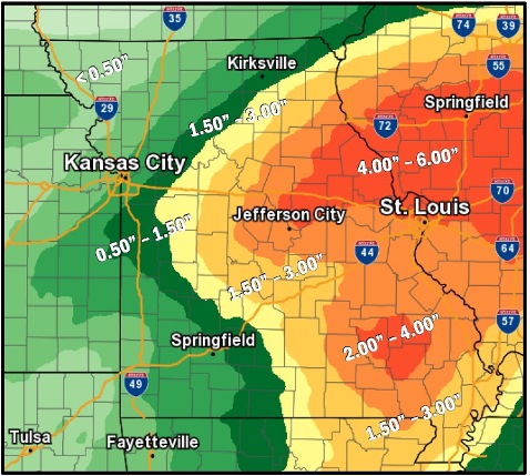
While there is a 90 percent chance of rain in today’s forecast, the center of the heavier rain is shifting to the east, according to the National Weather Service.
Moderate to heavy rain will continue through the afternoon and evening in the region, the weather service said.
Saturated ground in some areas of the region will not need much additional rainfall to increase river and flash flooding concerns, according to the weather service.
Some rivers, including the Missouri River, are already near or at flood stage in many places, the weather service said, and additional rainfall amounts may increase river flooding to the east of Kansas City.
Kansas City at this time could be one place in the region that is not flooding, surrounded by flooding in other cities.
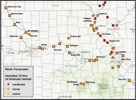
The Missouri River at Kansas City was at 22.81 feet at 8:30 a.m. Sept. 7, with the flood stage at 32 feet, according to the hydrology charts.
The Kansas River in Kansas City, Kansas, was 24.3 feet at 8:45 a.m. Sept. 7, where flood stage is 33 feet.
Turkey Creek at Southwest Boulevard was at 48.31 feet at 8:16 a.m. Sept. 7, wth flood stage at 61 feet.
Other cities, however, that are experiencing some flooding, according to hydrology charts, include:
• Leavenworth, where the Missouri River was at action stage, 19.08 feet at 8 a.m. Sept. 7, with flood stage at 20 feet;
• Platte River at Sharp’s Station, action stage, 22.24 feet at 8:30 a.m. Sept. 7, flood stage is 26 feet;
• Missouri River at Atchison, minor flooding, 23.22 feet at 8 a.m. Sept. 7, flood stage is 22 feet;
• Missouri River at St. Joseph, minor flooding, 20.58 feet at 8:30 a.m. Sept. 7, flood stage is 17 feet;
• Missouri River at Sibley, Missouri, action stage, 21.3 feet at 9:54 p.m. Sept. 6, flood stage is 22 feet;
• Missouri River at Napoleon, Missouri, minor flooding, 18.34 feet at 9 a.m. Sept. 7, flood stage is 17 feet;
• Missouri River near Waverly, Missouri, minor flooding, 21.68 feet at 8:30 a.m. Sept. 7, flood stage is 20 feet.
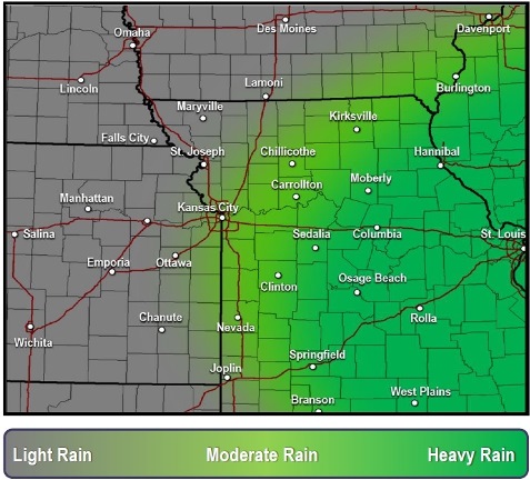
Today’s forecast for Wyandotte County includes a 90 percent chance of showers and possibly a thunderstorm, the weather service said. There will be patchy fog before 11 a.m., with a high of 72 and a northeast wind of 9 mph. Between a quarter and half-inch of rain is expected.
Tonight, there is a 50 percent chance of showers and thunderstorms, with a low of 63 and a north northeast wind of 9 to 11 mph, according to the weather service. Between a tenth and quarter-inch of rain is expected.
Saturday, there is a 40 percent chance of showers, mainly before 1 p.m., the weather service said. It will be cloudy with a high near 69 and a north northeast wind of 10 to 13 mph, gusting as high as 24 mph. Less than a tenth of an inch of rain is possible.
Saturday night, the low will be around 58 with a northeast wind of 7 to 11 mph, according to the weather service.
Sunday, the high will be near 74 with mostly sunny skies and a north northeast wind around 7 mph, the weather service said.
Sunday night, the low will be around 57 with partly cloudy skies, according to the weather service.
Monday, it will be sunny with a high near 78, the weather service said.
Monday night, it will be mostly clear with a low of 61, according to the weather service.
Tuesday, it will be sunny with a high near 80, the weather service said.
Tuesday night, the low will be 64 with mostly clear skies, according to the weather service.
Wednesday, it will be sunny with a high near 83, the weather service said.
Wednesday night, it will be mostly clear with a low of 66, according to the weather service.
Thursday, it will be sunny with a high near 83, the weather service said.