Light to moderate rain will continue today, and there is a dense fog advisory in effect until 11 a.m. today, according to the National Weather Service.
Visibility will be reduced to one-quarter of a mile or less, the weather service said. If driving, residents should slow down, use headlights and leave plenty of distance ahead of them.
Rain activity today should be spotty and scattered with only minor accumulations, according to the weather service.
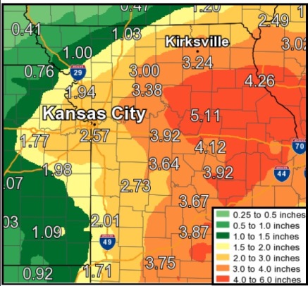
Tonight will bring another round of widespread light to moderate rain, resulting in widespread 1-plus inch amounts, with some areas seeing 2-3 inches, the weather service said.
Friday and Friday night will bring another round of rain, which will likely add another 1-2 inches across the area, with some areas likely receiving more, according to the weather service.
Flash flooding in the region will be possible beginning tonight and lasting through early Saturday, the weather service said.
A glance at the hydrology charts showed the Missouri and Kansas rivers in Wyandotte County were well below flood level on Wednesday morning. The Missouri River at Kansas City was at 22.51 feet where flood stage is 32 feet. The Kansas River in Wyandotte County was 24.08 feet where flood stage is 33 feet. Turkey Creek was 48.31 feet where flood stage is 61 feet.
The Missouri River at Leavenworth was in the action stage at 19.7 feet, where the flood stage is 20 feet.
Today, there is a 40 percent chance of showers and thunderstorms, with a high near 75, the weather service said, and a northeast wind of 3 to 8 mph. Between a tenth and quarter-inch of rain is possible.
Tonight, there is a 60 percent chance of showers and thunderstorms, with more rain and possibly a storm after 4 a.m., according to the weather service. The low will be around 66 with a northeast wind of 8 mph. Between a tenth and quarter-inch of rain is possible.
Friday, there is a 60 percent chance of showers and a thunderstorm before 1 p.m., with a chance of showers and thunderstorms after 1 p.m., the weather service said. Patchy fog will be possible in the morning. The high will be near 71 with a northeast wind of 8 mph. Between a half and three-quarters of an inch of rain is possible.
Friday night, there is a 60 percent chance of showers and thunderstorms, with possibly a thunderstorm after 1 a.m., according to the weather service. The low will be around 63 with a northeast wind of 8 to 10 mph. Between three-quarters and 1 inch of rain is possible.
Saturday, there is a 50 percent chance of showers and thunderstorms before 1 p.m., then a slight chance of thunderstorms after 1 p.m., the weather service said. The high will be near 70 with a northeast wind of 9 to 13 mph, gusting as high as 21 mph. Between a half and three-quarters inch of rain is possible.
Saturday night, there is a 20 percent chance of thundrstorms before 1 a.m., with a low of 60, according to the weather service.
Sunday, it will be partly sunny with a high near 72, the weather service said.
Sunday night, it will be partly cloudy with a low of 59, according to the weather service.
Monday, it will be sunny with a high near 77, the weather service said.
Monday night, it will be mostly clear, with a low of 61, according to the weather service.
Tuesday, it will be sunny with a high near 81, the weather service said.