Showers and scattered thunderstorms will affect much of the lower Missouri Valley today through Thursday, according to the National Weather Service. Widespread severe weather is not expected at this time.
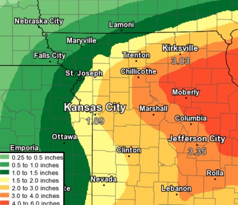
The combination of a tropical airmass along with very efficient rains will lead to heavy rain and increasing threat for flooding and flash flooding both today and Thursday, the weather service said.
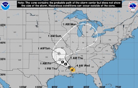
In addition, persistent and very efficient rains will further prime the soil for possible more widespread flooding later this week when the remnants of Hurricane Gordon move through the area, according to the weather service.
With several days of rainfall expected, and with the potential rain amounts, flooding will be a concern across the entire area through the upcoming weekend, the weather service said.
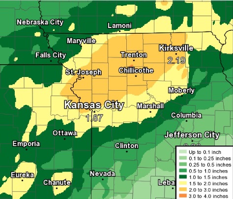
The track and location of heavier rain will depend upon several factors, which may change, according to the weather service. Forecast rainfall amounts and locations will be adjusted as forecasters approach the end of the week.
The remnants of Hurricane Gordon are expected to lift north into the lower Missouri Valley by the weekend, the weather service said.
Abundant moisture associated with this system will move into the region which could lead to widespread heavy rainfall and the threat for additional flash flooding through the late week and early weekend, according to the weather service.
At 9 a.m. Sept. 5, the Kansas and Missouri rivers in Wyandotte County were not in flood stage, according to hydrology charts. The Missouri River at Kansas City was about 10 feet below flood stage. The Kansas River in Kansas City, Kansas, also was about 10 feet below flood stage on Wednesday morning.
However, the Missouri River at Leavenworth was in the action stage, according to a hydrology chart.
Today, there is an 80 percent chance of showers and thunderstorms, then showers and possibly a thunderstorm after 10 a.m., the weather service said. The high will be near 78 with a south southwest wind of 6 mph becoming calm in the afternoon. Between three-quarters and 1 inch of rain is expected.
Tonight, there is a 60 percent chance of showers and possibly a thunderstorm, with a low of 68 and a northeast wind of 6 mph, according to the weather service. Between a quarter and half-inch of rain is possible.
Thursday, the forecast calls for a 60 percent chance of rain and storms before 2 p.m., then a chance of showers and thunderstorms after 2 p.m., the weather service said. The high will be near 77 with a northeast wind of 6 to 8 mph. Between a quarter and half-inch of rain is possible.
Thursday night, there is a 60 percent chance of showers and thunderstorms, then shows are likely and a possible thunderstorm after 2 a.m., according to the weather service. The low will be 67 with a northeast wind of 6 to 9 mph. Between a half and three-quarters inch of rain is expected.
Friday, there is a 60 percent chance of showers and possibly a thunderstorm before 2 p.m., then a chance of showers and thunderstorms after 2 p.m., the weather service said. The high will be near 73 with a northeast wind of 6 to 9 mph. Between a half and three-quarters of an inch of rain is possible.
Friday night, there is a 50 percent chance of showers and thunderstorms with a low of 65, according to the weather service. Between three-quarters and 1 inch of rain is possible.
Saturday, there is a 50 percent chance of showers before 2 p.m., with a high near 70, the weather service said.
Saturday night, it will be mostly cloudy with a low of 61, according to the weather service.
Sunday, it will be partly sunny with a high of 73, the weather service said.
Sunday night, it will be mostly cloudy with a low of 62, according to the weather service.
Monday, it will be mostly sunny with a high near 78, the weather service said.
Monday night, it will be partly cloudy with a low of 64, according to the weather service.
Tuesday, it will be sunny with a high near 81, the weather service said.