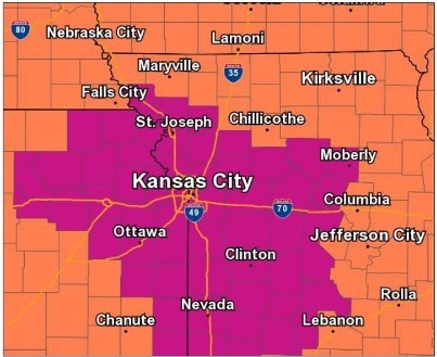
An excessive heat warning remains in effect for areas along and south of the Missouri River, according to the National Weather Service.
The excessive heat warning will be in effect through 7 p.m. Saturday, June 30.
Highs today will climb to 98 with a heat index of about 105, the weather service said.
For a list of cooling centers, see https://www.facebook.com/notes/kansas-city-kansas-unified-government/cooling-centers-spray-parks-and-pools/2505697519455873/.
On Saturday, highs are expected to be near 96 with a heat index of 104, according to the weather service.
There will also be little relief during the overnight hours, as lows Saturday morning will fall only to 74.
Today will be the warmest of the next two days, according to the weather service.
Moderate river flooding is expected along the Missouri River from Nebraska City down through St. Joseph, Missouri, according to the weather service. This will cause flooding in low-lying rural areas along the river not protected by levees. Minor flooding is expected further downstream with little impact.
The Missouri River at Atchison is in the action stage and is expected to go into minor flood stage on Friday, according to hydrology charts.
The Missouri River at Leavenworth is projected to go into the action stage on Friday.
The Missouri River at Kansas City is expected to stay under flood stage, according to National Oceanic and Atmospheric Administration hydrology charts. The Kansas River in Kansas City, Kansas, also is well under flood stage currently, according to hydrology charts.
Today, it will be sunny and hot, with a high near 98 and a heat index as high as 105, the weather service said. A south southwest wind of 11 to 16 mph will gust as high as 23 mph.
Tonight, expect a low of 78, with clear skies and a south wind of 10 to 15 mph, gusting as high as 24 mph, according to the weather service.
Saturday, it will be sunny with a high near 96 and heat index values as high as 104, the weather service said. A south wind of 10 to 13 mph will gust as high as 22 mph.
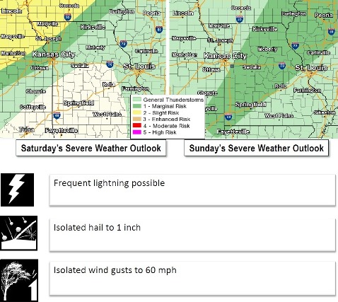
Saturday night, there is a 50 percent chance of showers and thunderstorms, with a low of 74, according to the weather service, and a south wind of 8 to 13 mph. Between a tenth and quarter-inch of rain is possible.
Sunday, there is a 30 percent chance of showers and thunderstorms, with a high near 87, the weather service said, and a southwest wind of 9 mph. Less than a tenth of an inch of rain is expected.
Sunday night, it will be partly cloudy with a low of 69, according to the weather service.
Monday, it will be sunny with a high near 91, the weather service said.
Monday night, it will be mostly clear with a low around 74, according to the weather service.
Tuesday, it will be sunny with a high near 94, the weather service said.
Tuesday night, the low will be around 75 with mostly clear skies, according to the weather service.
On Independence Day, Wednesday, the forecast is sunny with a high near 94, the weather service said.
On Wednesday night, the low will be around 74 with mostly clear skies, according to the weather service.
Thursday, it will be mostly sunny with a high near 93, the weather service said.