A sunny weekend with no rain is ahead for Wyandotte County, according to the National Weather Service forecast.
There is a chance for storms, possibly strong to severe, to return to the area Tuesday through Wednesday night, according to the weather service.
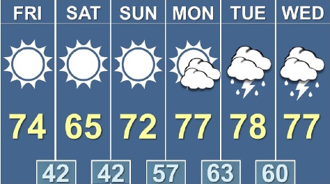
Today’s high will be near 73 with sunny skies and a light west wind, increasing to 6 to 11 mph in the morning, the weather service said. A dry cold front will move through the area later today.
Tonight, the low will be around 44 with mostly clear skies and a west wind of 6 to 8 mph becoming north northeast after midnight, according to the weather service.
Saturday, it will be sunny with a high near 66, the weather service said, and a northeast wind of 6 to 8 mph.
Saturday night, the low will be around 44 with an east southeast wind of 7 mph, according to the weather service.
Sunday, the high will be near 73 with sunny skies and a south southeast wind of 7 to 13 mph, the weather service said.
Sunday night, the low will be around 57 with partly cloudy skies, according to the weather service.
Monday, the high will be near 78 with mostly sunny skies, the weather service said.
Monday night, the low will be around 63 with partly cloudy skies, according to the weather service.
Tuesday, expect a 30 percent chance of showers and thunderstorms after 1 p.m., with a high of 79, the weather service said.
Tuesday night, the low will be around 61 with a 70 percent chance of showers and thunderstorms, mainly after 1 a.m., according to the weather service.
Wednesday, there is a 40 percent chance of showers and thunderstorms, with a high of 78, the weather service said.
Wednesday night, there is a 50 percent chance of showers and thunderstorms, with a low of 56, according to the weather service.
Thursday, there is a high near 70 with partly sunny skies, the weather service said.