A mix of light snow and rain was falling around 8:40 p.m. Saturday, April 14, in Wyandotte County. The temperature was reported at 39 degrees.
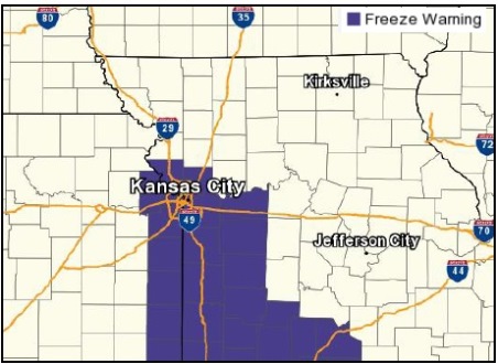
The forecast from the National Weather Service said light rain, drizzle and light snow are possible tonight. A freeze warning is in effect from 2 a.m. to 9 a.m. Sunday.
A dusting on lawns is the most snow that is expected, with little to no effect on travel, according to the weather service.
A hard freeze is expected for the Kansas City area, and sensitive outdoor plants should be protected tonight, the weather service said.
The forecast tonight calls for rain and snow showers before 1 a.m., then a chance of snow showers and freezing drizzle between 1 a.m. and 2 a.m., then a chance of snow showers after 2 a.m., according to the weather service.
A northwest wind of 13 to 18 mph may gust as high as 26 mph. Little or no ice accumulation is expected, with less than a half-inch of snow accumulation possible tonight.
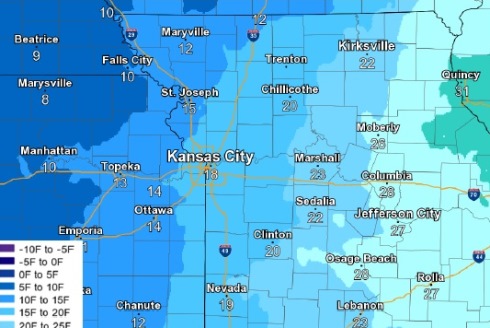
Sunday, it will be cloudy with a high near 37 and a northwest wind of 18 mph, gusting as high as 28 mph, the weather service said.
Sunday night, the low will be around 27, with a northwest wind of 9 to 15 mph, gusting as high as 23 mph, according to the weather service.
Monday, the forecast calls for sunny skies and a high near 54, with a west northwest wind of 5 to 8 mph, the weather service said.
For more weather information, visit www.weather.gov.