Severe storms are possible today, according to the National Weather Service.
Storms were moving through part of Wyandotte County around 8:45 a.m. Friday.
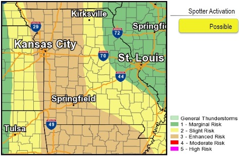
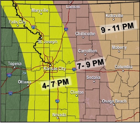
Severe storms also are possible late this afternoon and evening ahead of a cold front, the weather service said. Severe storms will develop over far east Kansas and western Missouri between 4 p.m. and 7 p.m., with activity quickly shifting east through the evening hours. Much of the activity will be east after 11 p.m.
Any storms that develop will have the potential to be severe with large hail and damaging winds being the most likely threats; however, a few isolated tornados will also be possible, according to the weather service.
Light snow is possible Saturday night into Sunday morning with very minor accumulations possible north of Kansas City. Below freezing temperatures are expected Sunday and Monday morning.
Today’s high will be near 79 with a south wind of 18 to 23 mph, gusting as high as 36 mph, the weather service said.
Tonight, there is a 50 percent chance of showers and thunderstorms before 11 p.m., then a slight chance of showers after 4 a.m., according to the weather service. The low will be around 42, with a south wind of 15 to 20 mph decreasing to 8 to 13 mph after midnight. Winds may gust as high as 31 mph. Between a tenth and quarter-inch of rain is possible.
Saturday, there is a 30 percent chance of showers, mainly between 1 p.m. and 4 p.m., then a chance of rain after 4 p.m., the weather service said. The high will be near 48 with a south southwest wind of 10 to 13 mph, gusting as high as 20 mph.
Saturday night, there is a 40 percent chance of rain before midnight, then a chance of rain and snow between midnight and 4 a.m., then a slight chance of snow and freezing rain after 4 a.m., according to the weather service. The low will be around 31 with a northwest wind of 13 to 16 mph, gusting to 28 mph.
Sunday, there is a 10 percent chance of freezing rain before 7 a.m., with a high near 41, the weather service said. A north northwest wind of 15 to 17 mph may gust as high as 28 mph.
Sunday night, the low will be around 27, according to the weather service.
Monday, it will be sunny with a high near 54, the weather service said.
Monday night, the low will be around 40, according to the weather service.
Tuesday, it will be mostly sunny with a high near 69, the weather service said.
For more weather information, see www.weather.gov.