A winter weather advisory is in effect for Wyandotte County from 6 p.m. Wednesday, Feb. 21, through noon Thursday, Feb. 22, according to the National Weather Service.
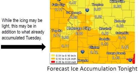
Sleet and freezing rain are expected through early Thursday afternoon, with up to one inch of sleet accumulations and up to two-tenths of an inch of ice accumulations, the weather service said.
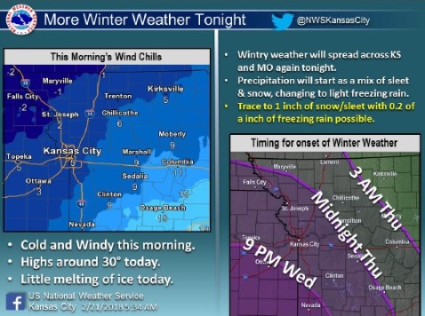
It was a cold start this morning, with temperatures at 19 degrees with a wind chill of 10 at 9 a.m. Today’s high will only be about 30 degrees, meaning that some of the previous ice on the ground and sidewalks may not melt today, according to the weather service.
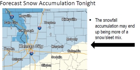
Tonight, precipitation is expected to start as a combination of sleet and snow, and will change through the night to freezing rain and drizzle, according to the weather service.
In the Kansas City area, this precipitation is expected to be more freezing rain, with up to two-tenths of an inch of additional icing possible through Thursday morning, according to the weather service.
Temperatures are expected to warm up to, or above, freezing by Thursday afternoon, bringing an end to this round of wintery weather, the weather service said.
Those who are driving in the weather are advised to be extra cautious, according to the weather service.
Today’s forecast is a high near 30 with a northeast wind of 5 to 11 mph, the weather service said.
Tonight, snow and sleet, possibly mixed with freezing rain, is possible before 3 a.m., then freezing rain is possible, perhaps mixed with sleet, according to the weather service. There is an 80 percent chance of precipitation. The low will be around 26 with an east northeast wind of 9 to 11 mph. Ice accumulation of less than a tenth of an inch is possible, and new snow and sleet accumulation of less than a half-inch is possible.
Thursday, there is a 40 percent chance of precipitation. There is a chance of freezing rain before noon, then a chance of freezing drizzle between noon and 1 p.m., followed by a chance of drizzle after 1 p.m., the weather service said. The high will be near 36 with an east wind of 5 to 9 mph. Less than a tenth of an inch of new precipitation is forecast.
Thursday night, there will be a chance of drizzle before 5 a.m., then a slight chance of freezing drizzle, according to the weather service. The low will be 31 with an east wind of 5 mph becoming calm in the evening.
Friday, the high will be near 45 with partly sunny skies, the weather service said. A light and variable wind will become east northeast around 5 mph in the afternoon.
Friday night, there will be a 50 percent chance of rain, with a low of 34, according to the weather service. Less than a tenth of an inch is possible.
Saturday, there is a 40 percent chance of rain with a high of 51, the weather service said.
Saturday night, there is a 30 percent chance of rain, mixing with snow after 11 p.m., then gradually ending, according to the weather service. The low will be around 28.
Sunday, the high will be near 51 with sunny skies, the weather service said.
Sunday night, the low will be around 29, according to the weather service.