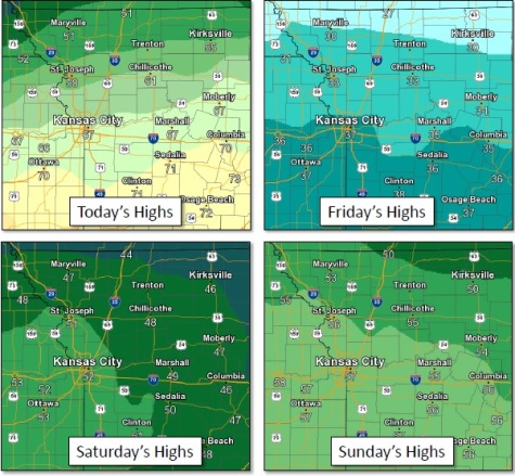
The temperature at 9 a.m. Thursday was 64 in the Kansas City area, according to the National Weather Service, and it was expected to climb to a high near 68 today.
The temperature could approach the record high in Kansas City for Feb. 15, which was 72 degrees in 1911, according to weather service records. The normal high for this date is 43 in Kansas City.
The weather service said today will be mostly cloudy, with a southwest wind of 9 to 13 mph becoming north northwest in the afternoon.
The warmup is short-lived, with temperatures falling 40 degrees to a low of about 22 Thursday night, with a north wind of 11 to 17 mph gusting to as high as 26 mph, according to the weather service.
Friday, it will be mostly sunny with a high of 36, the weather service said, and a north wind of 5 to 14 mph becoming east in the afternoon. Winds may gust as high as 20 mph.
Friday night, look for a low of 27 with mostly cloudy skies and a southeast wind of 5 to 7 mph.
Then the weather warms up again. Saturday, it will be mostly cloudy through mid-morning, then gradually clearing, with a high near 52, the weather service said. A south wind of 7 to 13 mph will become west in the afternoon. Winds may gust as high as 21 mph.
Saturday night, the low will be around 29 with mostly clear skies, according to the weather service.
Sunday, the high will be near 58 with sunny skies, the weather service said.
Sunday night, the low will be around 46 with mostly cloudy skies.
Monday, Presidents Day, there is a 60 percent chance of showers, mainly after noon, with a high of 65, the weather service said.
Monday night, expect a 40 percent chance of rain showers before 11 p.m., then a chance of snow showers, the weather service said. The low will be around 26.