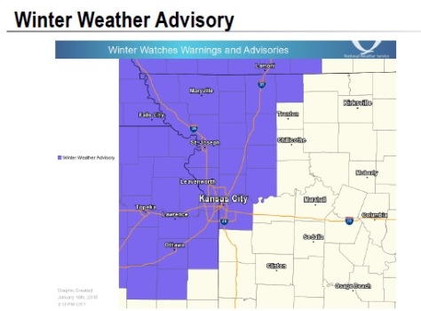
A winter weather advisory will be in effect from 8 a.m. through 3 p.m. Thursday, Jan. 11, according to the National Weather Service.
Light freezing rain and a wintry mix are expected from 8 a.m. to 3 p.m. Thursday, the weather service said. The ice will result will result in very slippery conditions on sidewalks, roads and bridges, resulting in difficult travel conditions.
A total ice accumulation of several hundredths of an inch is possible, according to the weather service.
Wet surfaces from morning rainfall and light freezing rain will freeze and become slick and hazardous as temperatures fall below freezing, the weather service said.
Motorists are advised to slow down and use caution while driving. For the latest road conditions, call 511. In the Kansas City area, visit www.kcscout.net for highway conditions.
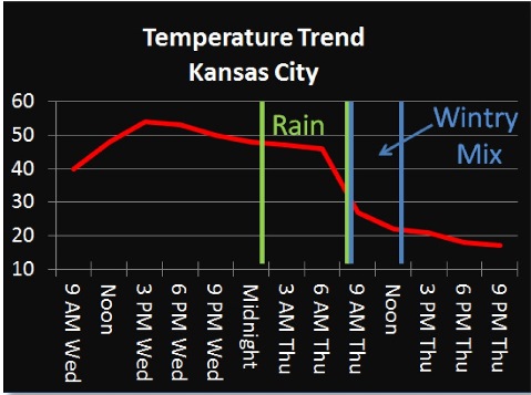
Residents can expect rain after 1 a.m. tonight, and a low of 33. About a quarter to half-inch of rain is possible.
On Thursday, rain showers and freezing rain are possible before 11 a.m., with snow showers also possible. A winter mix of snow showers and possibly freezing rain will continue between 11 a.m. and noon. After that, there is a slight chance of snow, according to the weather service.
Temperatures will fall to about 19 degrees by 5 p.m. It will be windy on Thursday, and new ice accumulation of less than a tenth of an inch is possible, along with snow accumulation of less than a half-inch.
Thursday night, the low will be around 10, with a wind chill reading between minus 2 and 3. A north northwest wind of 8 to 15 mph may gust as high as 26 mph.
Friday will be cloudy with a high near 25, and a wind chill of between minus 2 and 8. The north wind will be 6 to 8 mph.
For more weather information, visit www.weather.gov.