Drizzle is expected through the day, according to the National Weather Service.
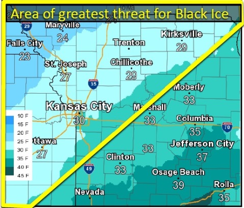
Drizzle may persist behind the cold front as temperatures fall this evening, possibly leading to the development of black ice, especially on elevated surfaces, the weather service said.
Temperatures are expected to be cold through the weekend, with a chance of snow Sunday. There is little to no snow accumulation expected, according to the weather service.
Today, there is a chance of drizzle in the forecast. Patchy fog is possible before 2 p.m. The high will be near 51 with an east wind of 5 to 7 mph becoming north in the afternoon, the weather service said.
Tonight, patchy drizzle is possible between 9 p.m. and 5 a.m., according to the weather service. The low will be around 29 with a north wind of 8 to 10 mph.
Friday, it will be mostly cloudy with a high near 36, the weather service said. There will be a north northwest wind of 5 to 7 mph.
Friday night, it will be mostly cloudy, then gradually clearing, with a low of 23, according to the weather service. There will be a north northwest wind of 3 to 5 mph.
Saturday, the high will be near 34 with mostly sunny skies and a north wind of 5 to 8 mph, the weather service said.
Saturday night, there will be a 20 percent chance of snow after midnight, according to the weather service. The low will be around 19.
Sunday, there is a 30 percent chance of snow before noon. It will be mostly sunny with a high of 32, the weather service said.
Sunday night, Christmas Eve, it will be mostly clear with a low of 21, according to the weather service.
Monday, Christmas Day, it will be partly sunny with a high near 37, the weather service said.
Monday night, the low will be around 20 with partly cloudy skies, according to the weather service.