A few showers and thunderstorms may bring rain and snow to Wyandotte County today, according to the National Weather Service.
It will be half as warm Sunday as it was Saturday.
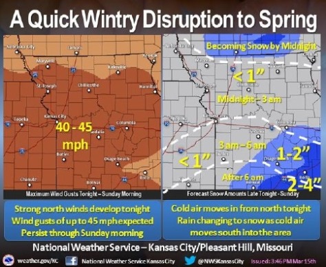
A strong cold front will push southward through the area tonight with strong winds developing behind the front, the weather service said.
Winds could gust as high as 45 mph before the front.
Temperatures also will drop quickly, allowing a transition from rain to snow to occur from north to south tonight.
There will likely be a period of sleet as well during the transition.
Most areas will see less than an inch of snow from this storm.
At 6 p.m., storm clouds were in the Topeka, Manhattan, Leavenworth and Emporia, Kan., areas.
Before 5 a.m. Sunday, rain showers are likely.
The weather service forecast shows a slight chance of thunderstorms at 9 p.m. Saturday, showers likely at midnight, then rain likely at 3 a.m.
After 5 a.m., rain and sleet are likely. The weather service forecast shows snow likely at 6 a.m. Sunday, chance of snow at 9 a.m., slight chance of wintry mix at noon, slight chance of rain and snow from 2 to 3 p.m., and mostly cloudy skies at 3 p.m. Sunday.
The high Sunday will be near 36.