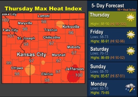
The heat index may rise to 97 this afternoon as warm weather has returned to Wyandotte County.
According to the National Weather Service, warm conditions will persist through the weekend, with heat indices each day eclipsing 90 degrees.
Normal highs for mid to late September are between 75 and 80 degrees, so these temperatures are 20 to 25 degrees above normal, the weather service said.
Storms are in the forecast for early next week, and at this time, widespread severe weather is not anticipated, according to the weather service.
Those who are outside today should drink plenty of fluids and take frequent breaks, according to the weather service.
The high may reach 88 degrees, with a heat index of 97, today, the weather service said. The skies will be mostly sunny with a south wind of 6 to 15 mph, with winds gusting to 21 mph.
Tonight, it will be mostly clear with a low of 72 and a south wind of 7 to 11 mph, according to the weather service.
Friday, it will be sunny with a high of 88 and a south wind of 6 to 10 mph, the weather service said.
Friday night, it will be mostly clear with a low of 72 and a south southeast wind of 5 to 8 mph, according to the weather service.
Saturday, it will be sunny with a high near 87 and a south wind of 6 to 9 mph, the weather service said.
Saturday night, it will be mostly clear with a low of about 70, according to the weather service.
Sunday, it will be sunny with a high near 86, the weather service said.
Sunday night, it will be partly cloudy with a low of 67, according to the weather service.
Monday, there will be a 50 percent chance of showers and thunderstorms, with a high near 83, the weather service said.
Monday night, there is a 40 percent chance of showers and thunderstorms, with a low of 63, according to the weather service.