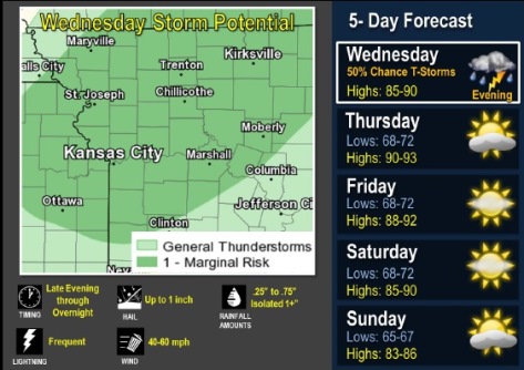
There is a 40 percent chance of storms and rain tonight, according to the National Weather Service.
Strong to severe storms are possible, the weather service said. Hail up to quarter-sized and gusty winds will be possible, but probably will not be widespread, according to the weather service.
The Wyandotte County forecast for tonight calls for new rainfall amounts between a tenth and quarter-inch, mainly after 7 p.m. The low will be around 73 degrees.
Temperatures will rise for the rest of the week and into the weekend, with highs in the upper 80s to lower 90s Thursday through Saturday, according to the weather service. Storms again are possible early next week, but severe weather is not anticipated.
The high today will be near 86 with south southwest winds of 7 to 14 mph, gusting to 18 mph, the weather service said.
On Thursday, the high will be near 89 with mostly sunny skies and a heat index as high as 97, according to the weather service. A south wind of 8 to 11 mph is expected, with gusts as high as 18 mph.
Thursday night, expect mostly clear skies with a low of 72 and a south wind of 7 to 10 mph, according to the weather service.
Friday, it will be sunny with a high near 88 and a south wind of 7 to 10 mph, according to the weather service.
Friday night, expect mostly clear skies with a low of 70, the weather service said.
Saturday, it will be sunny with a high near 88, the weather service said.
Saturday night, expect mostly clear skies and a low of 68, according to the weather service.
Sunday, it will be mostly sunny with a high near 85, the weather service said.
Sunday night, it will be partly cloudy with a low of 66, according to the weather service.
Monday, there is a 50 percent chance of showers and thunderstorms, with a high near 82, the weather service said.
For more weather information, visits www.weather.gov.