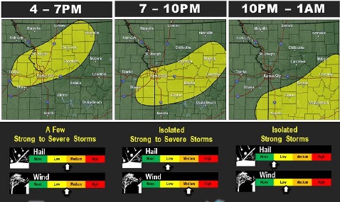
A cold front will be moving into the area this afternoon that will help develop some strong to severe storms along it in the afternoon, according to the National Weather Service.
The initial threat will be large hail and damaging winds which will transition to mostly damaging winds as it forms into a line near sunset, the weather service said.
Benign weather returns for this weekend with temperatures creeping back up into the upper 80s to some lower 90s by Sunday, according to the weather service. Heat index values will be in the upper 90s by Sunday.
Today, there is a 30 percent chance of showers and thunderstorms, mainly after 4 p.m., the weather service said. The high will be near 88 with a calm wind becoming southwest 5 to 9 mph in the morning.
Tonight, there is a 40 percent chance of showers and thunderstorms before 1 a.m., according to the weather service. The low will be around 65, with a south southwest wind of 5 to 7 mph becoming calm in the evening. Between a tenth and quarter inch of rain is possible.
Saturday, it will be sunny with a high near 90, the weather service said. A calm wind will become south southwest around 5 mph in the afternoon.
Saturday night, there is a 20 percent chance of showers and thunderstorms after 1 a.m., according to the weather service. The low will be 69 with a light southeast wind.
Sunday, expect a 20 percent chance of showers and thunderstorms after 1 p.m., the weather service said. The high will be near 90, with a south wind of 3 to 7 mph.
Sunday night, there is a 30 percent chance of showers and storms, mainly after 1 a.m., according to the weather service. The low will be 73.
Monday, the day of the solar eclipse, there is a 30 percent chance of showers with a high near 90, the weather service said. It will be partly sunny.
Monday night, there is a 40 percent chance of showers and thunderstorms after 1 a.m., according to the weather service. The low will be around 74.
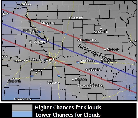
For Monday, Aug. 21, the weather service said a trend in the model data has been a line of thunderstorms developing along the Iowa-Missouri border into Iowa Sunday night into Monday morning.
An upper level jet stream is expected to move into Kansas overnight creating the possibility of upper-level clouds that may move over the region during the time of the eclipse, according to the weather service. These are very thick clouds with little breaks, usually, but the placement of the band of clouds varies in some of the models, so there is still hope that the clouds will go north and west that day, according to the weather service.
It is still considered too early to know the forecast for the day of the eclipse, but currently, it appears that it might be cloudy, and the forecast may change.