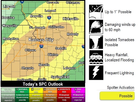
The National Weather Service says that storms this afternoon into tonight may become strong to severe.
Storms may start developing between 4 and 6 p.m. today in eastern Kansas and then move east through the night, according to the weather service.
However, this morning’s storms could keep the weather from destabilizing, which would lessen the evening’s severe potential, the weather service said.
If the weather destabilizes, the initial threat will be isolated tornadoes, large hail and damaging wind, then changing to more of a damaging wind threat with large hail possible, according to the weather service.
In addition, moderate to heavy rainfall occurring for long periods of time in the same areas could lead to local flooding, the weather service said.
Storms look to clear out by early Thursday morning, and the next chance for potentially strong storms will be Friday afternoon to Friday night, according to the weather service.
Today, there is a 90 percent chance of showers and thunderstorms, mainly before 2 a.m., with a high near 88, the weather service said. The heat index could reach as high as 96. There will be a south wind of 6 to 13 mph. Between a quarter and a half-inch of rain is possible.
Tonight, expect a 70 percent chance of showers and thunderstorms, mainly before 1 a.m. The low will be around 68 with a south wind of 6 to 11 mph becoming west after midnight. Between three-quarters and an inch of rain is possible.
Thursday, there is a 10 percent chance of showers and thunderstorms before 7 a.m., the weather service said. It will be mostly sunny with a high near 83 and a west northwest wind of 6 to 8 mph.
Thursday night, it will be mostly clear with a low of 64, according to the weather service. A west northwest wind of 6 mph will become calm in the evening.
Friday, there is a 20 percent chance of showers and thunderstorms after 1 p.m., with a high near 87. A calm wind will become south southwest 5 to 7 mph in the afternoon.
Saturday, it will be sunny with a high near 86, the weather service said.
Saturday night, it will be mostly clear with a low of 67, according to the weather service.
Sunday, it will be sunny with a high near 88, the weather service said.
Sunday night, it will be partly cloudy with a low of 72, according to the weather service.
Monday, it will be mostly sunny with a high near 87, the weather service said.
Monday night, there is a 40 percent chance of showers and thunderstorms, with a low of 73, according to the weather service.
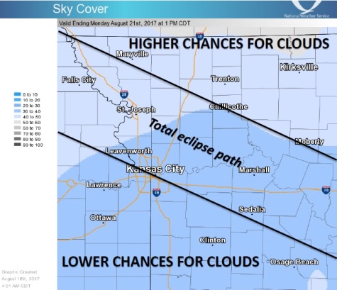
The forecast for Monday, Aug. 21, the day of the solar eclipse, forecasters are still not certain if clouds will be in the skies because of the variability in models they are using. Although it now appears that the area may not be stormy that day, there is a slight chance of clouds that day, according to the weather service, and there is a chance the forecast will continue to change as Aug. 21 gets closer. The chance for strong or severe storms that day is low, according to the weather service.