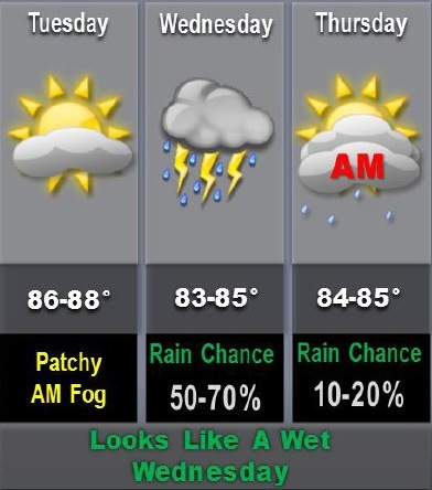
After temperatures in the 80s today, the weather forecast shows storms and showers may move through the region tonight and Wednesday.
According to the National Weather Service, a cold front will bring rain to the region on Wednesday morning, lasting through Thursday morning.
While severe weather is unlikely, a few strong storms are possible, with large hail the main threat, the weather service said.
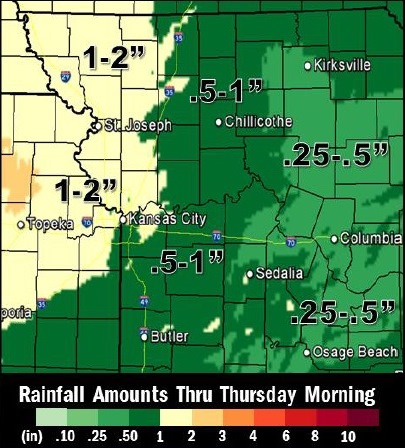
Some areas could receive up to 2 inches of rainfall with locally higher amounts, according to the weather service. Isolated flooding is possible Wednesday night as a result.
Today, it will be partly cloudy with a high in the upper 80s, and light and variable winds becoming southeast around 10 mph in the afternoon, the weather service said.
Tonight, expect a 40 percent chance of showers and storms after midnight, with lows in the lower 70s, according to the weather service. Southeast winds of 10 mph in the evening will become light and variable.
Wednesday, there is a 60 percent chance of showers and thunderstorms, with highs in the mid-80s, the weather service said. Light and variable winds will become south around 10 mph in the afternoon.
Wednesday night, there is a 70 percent chance of precipitation, with showers and thunderstorms likely in the evening, according to the weather service. Lows will be in the upper 60s with south winds around 10 mph in the evening becoming light and variable.
Thursday, the high will be in the mid-80s, with partly cloudy skies, the weather service said. Light and variable winds will become northwest around 10 mph in the afternoon.
Thursday night, it will be mostly clear with a low in the mid-60s, according to the weather service.
Friday, the high will be in the mid-80s with partly cloudy skies, the weather service said.
Friday night, it will be partly cloudy with a 40 percent chance of showers and thunderstorms, and a low in the upper 60s, according to the weather service.
Saturday, the high will be in the mid-80s with partly cloudy skies, the weather service said.
Saturday night, the low will be in the upper 60s, according to the weather service.
Sunday, expect highs in the upper 80s and lows in the upper 60s, with mostly clear skies, the weather service said.
Monday, it will be partly cloudy with highs in the upper 80s, the weather service said.
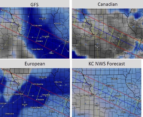
On Monday, the day of the solar eclipse, the weather service said different long-range computer models are showing different locations for storms on Sunday night and clouds on Monday. There is still uncertainty about the cloud coverage at 1 p.m. Aug 21, according to the weather service.