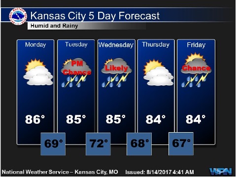
After a partly sunny day on Monday with a high of 86, the weather could start to change Tuesday, according to the National Weather Service.
Tonight will bring a 20 percent chance of showers and thunderstorms after 10 p.m., the weather service said. The low will be around 69 with a south wind of 5 to 8 mph.
There are several rounds of showers and thunderstorms possible this week, according to the weather service.
Tuesday, there will be a 20 percent chance of showers and thunderstorms, with a high near 85, and a south southeast wind of 3 to 8 mph, the weather service said.
On Tuesday night and Wednesday, the storms may be strong, according to the weather service. Some areas in the region may receive 2 to 3 inches of rain.
Tuesday night in Wyandotte County, there is a 40 percent chance of showers and storms, with a low of 73, according to the weather service, and a south southeast wind of 7 mph. Between a tenth and quarter of an inch of rain is possible.
Wednesday, there is a 60 percent chance of showers and thunderstorms, mainly after 1 p.m., with a high near 86, the weather service said. A south southwest wind of 6 to 10 mph is possible. Between a quarter and a half-inch of rain is in the forecast.
Wednesday night, there is a 60 percent chance of showers and thunderstorms likely, mainly before 1 a.m., according to the weather service. The low will be around 70. Between a quarter and half-inch of rain is possible.
Thursday, expect mostly sunny skies with a high of 86, the weather service said.
Thursday night, skies will be partly cloudy with a low of 68, according to the weather service.
Friday, the high will be near 85 with partly sunny skies, the weather service said.
Friday night, there is a 30 percent chance of showers and thunderstorms, with a low of 68, according to the weather service.
Saturday, expect mostly sunny skies with a high near 86, the weather service said.
Saturday night, it will be mostly clear with a low of 68, according to the weather service.
Sunday, expect mostly sunny skies with a high near 86, the weather service said.
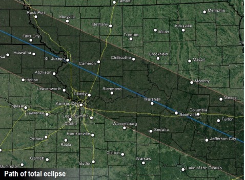
The forecast for Monday, Aug. 21, the day of the total eclipse, is still a bit uncertain, according to the weather service. Most weather models are depicting a complex of storms affecting the area during the morning hours but clearing in time for the afternoon eclipse, according to the weather service. Since this is a long-range forecast, exact details such as cloud cover and precipitation chances will not be known until later in the week, according to the weather service.