A flood warning is in effect until 1:45 p.m. Sunday, according to the National Weather Service.
At 1:49 a.m. Sunday, local officials reported flooding over multiple roadways throughout a wide area including Wyandotte County, the weather service said.
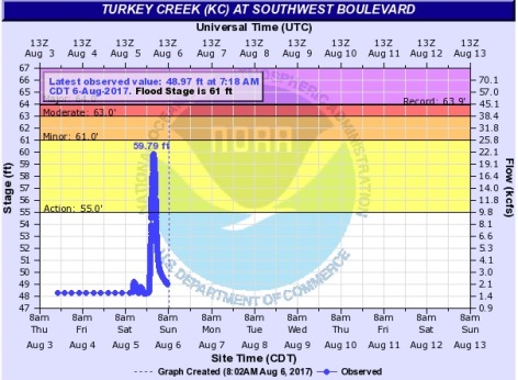
Four to 6 inches of rain have fallen over the area since Saturday afternoon, according to the weather service.
Besides Kansas City, Kansas, areas that are under the flood warning include Overland Park, Olathe, Independence, Lee’s Summit, Shawnee, Blue Springs, Lenexa, Leavenworth, Leawood, Raytown, Liberty, Gladstone, Grandview, Belton, Prairie Village, Sedalia, Raymore, Gardner and Warrensburg.
Rain showers will steadily taper off through Sunday morning, according to the weather service. Dry conditions will return by early afternoon, but flooding could remain a concern.
Unseasonably cool temperatures will persist through the week ahead, the weather service said.
Today’s high will be near 75 with a north northeast wind of 3 to 7 mph, the weather service said.
Tonight, it will be mostly cloudy with a low of 62 and a northeast wind of 3 to 6 mph, according to the weather service.
Monday, expect mostly cloudy skies with a high near 77 and a northeast wind of 6 mph, the weather service said.
Monday night, the low will be 62 with a northeast wind of 3 to 6 mph, according to the weather service.
Tuesday, the high will be near 80 with an east wind of 3 to 6 mph, the weather service said.
Tuesday night, the low will be 63, according to the weather service.
Wednesday, there is a 30 percent chance of rain and storms after 1 p.m., with a high of 80, the weather service said. Severe weather is not anticipated.