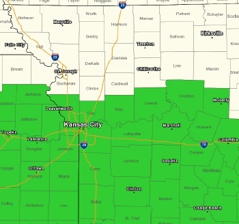
A flash flood watch is in effect from 10 a.m. Aug. 5 until 7 a.m. Aug. 6, according to the National Weather Service.
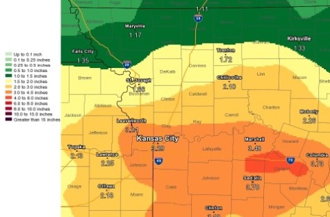
Widespread rainfall amounts of 2 to 4 inches will be likely today through midday Sunday, with locally higher amounts possible, the weather service said.
The focus for much of the highest rainfall totals, and subsequent flooding potential, will generally resident along and south of I-70, according to the weather service.
Locations that have recently received heavy rainfall will be at a higher risk for flooding potential, especial in the Kansas City metro area, where the urban environment adds another layer of concern, the weather service said.
A flash flood watch remains in effect from 10 a.m. Saturday morning through 7 a.m. Sunday, according to the weather service.
Flash flooding could occur rapidly, especially along creeks, streams and rivers, the weather service said.
Low water crossings and other flood prone areas could see quick rises once rainfall begins, especially in areas that have already had recent heavy rainfall, according to the weather service.
Residents who come upon water in the roadways are advised to turn around and go back.
The Wyandotte County forecast calls for an 80 percent chance of showers with thunderstorms also possible after noon Saturday, the weather service said. Some of the storms could produce heavy rain. The high will be near 73, with a southeast wind of 5 to 10 mph gusting as high as 18 mph. Between 1 and 2 inches of rain are possible.
Tonight, there is an 80 percent chance of showers and thunderstorms before 1 a.m., then more showers are likely and possibly a thunderstorm between 1 a.m. and 3 a.m., then showers are likely after 3 a.m., according to the weather service. Some of the storms could produce heavy rain. The low will be 66 with an east southeast wind of 9 mph. Between 2 and 3 inches of rain are possible.
Sunday, there is a 40 percent chance of showers before noon, then a chance of showers and thunderstorms between noon and 1 p.m., the weather service said. The high will be near 77, with an east southeast wind of 7 mph becoming north northeast in the afternoon. New rainfall amounts of a tenth to a quarter of an inch of rain are possible.
Sunday night, it will be mostly cloudy, with a low of 63 and a north northeast wind of 3 to 7 mph, according to the weather service.
Monday, it will be partly sunny, with a high near 78 and a northeast wind of 5 to 7 mph, the weather service said.
Monday night, it will be mostly cloudy with a low of 62, according to the weather service.
Tuesday, it will be partly sunny, with a high near 79, the weather service said.