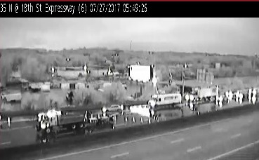
Update: Flash flooding has been reported in the Kansas City area. Southbound I-35 was closed at 18th Street Expressway because of flooding, according to a highway spokesman.
Update: Bulletin:
The National Weather Service has issued a flash flood warning for northern Wyandotte County, as well as northern Leavenworth County, Clay County, Platte County and central Jackson County.
At 1:33 a.m., radar indicated thunderstorms producing heavy rain across the area. Areas just north of downtown Kansas City, Mo., saw close to 6 inches of rain from a previous round of storms.
Additional rainfall amounts of 2 to 4 inches are possible through the night.
Flash flooding is occurring or expected to begin shortly.
Turn around, don`t drown when encountering flooded roads. Most flood
deaths occur in vehicles.
Be especially cautious at night when it is harder to recognize the
dangers of flooding.
Excessive runoff from heavy rainfall will cause flooding of small
creeks and streams, urban areas, highways, streets and underpasses as
well as other drainage areas and low lying spots.
The National Weather Service has issued a flash flood warning for Wyandotte County in effect until 1:45 a.m. Thursday.
The warning is for northeastern Wyandotte County, southwestern Clay County, southeastern Platte County and northwestern Jackson County.
At 9:50 p.m. Wednesday, local law enforcement reported thunderstorms producing heavy rain across the warned area, the weather service said. Up to two inches of rain have already fallen, and flash flooding is expected to begin shortly.
Residents are advised to turn around and do not try to go through flooded areas. Be especially cautious at night.
The National Weather Service has expanded a flash flood watch to include Wyandotte County and surrounding counties.
The flash flood watch was issued until 7 a.m. Thursday.
Thunderstorms with heavy rain moved through Wyandotte County this evening and may continue tonight, with rainfall rates exceeding 2 inches per hour in places. Total amounts of 1 to 3 inches are possible, according to the weather service.
Excessive rainfall may result in flooding of low-lying or poor drainage areas, creeks and streams, as well as urban areas, the weather service said. In addition to the flash flood hazard, rising river levels also are possible, according to the weather service.
Residents are advised to monitor the weather and not try to cross flooded streets.