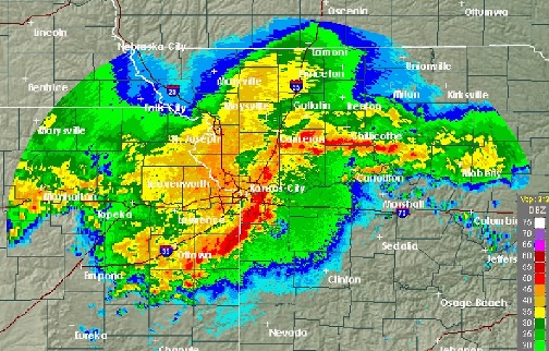
Hours of storms moved through Wyandotte County this morning, and more storms are expected today, according to the National Weather Service. That has resulted in a flash flood watch in effect now until 7 a.m. Friday, June 30.
Storms may linger into the early afternoon, the weather service said.
Strong to severe storms are possible across eastern Kansas this afternoon, then moving east late in the afternoon and evening.
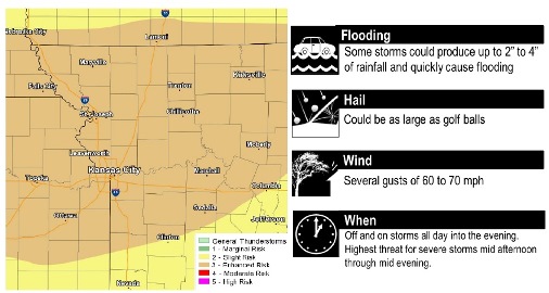
These storms could be severe with large hail, damaging winds and a few tornadoes, the weather service said. The tornado threat is less than Wednesday’s storm system.
Rainfall of up to an inch or two is possible in storms today, the weather service said. This evening, even heavier rain is possible, with some areas from 2 to 4 inches.
Flash flooding is possible, especially in areas in Missouri where heavy rain on Wednesday led to areas of flooding, according to the weather service.
Today, there is a 60 percent chance of rain, with a high near 89, the weather service said. The heat index will be as high as 96. A north northeast wind of 5 to 15 mph, gusting to 24 mph, changes to the south in the morning.
Tonight, there is a 60 percent chance of showers and thunderstorms likely, mainly between 10 p.m. and 4 a.m., according to the weather service. The low will be around 71 with a south wind of 5 to 14 mph, gusting as high as 24 mph. Between 1 and 2 inches of rain are possible.
Friday, there is a 30 percent chance of precipitation and storms, mainly before 7 a.m., the weather service said. The high will be near 83. A north northwest wind will be 5 to 8 mph.
Friday night, the low will be around 64 with a north northwest wind of 3 to 5 mph, according to the weather service.
Saturday, it will be sunny with a high near 85, the weather service said. A calm wind will become west northwest around 5 mph in the afternoon.
Saturday night, it will be mostly clear with a low of 66, according to the weather service.
Sunday, it will be mostly sunny with a high near 88, the weather service said.
Sunday night, there is a 60 percent chance of showers and thunderstorms, mainly after 1 a.m., the weather service said. The low will be around 70.
Monday, there is a 50 percent chance of showers and thunderstorms, with a high near 86, the weather service said.
Monday night, there is a 50 percent chance of showers and thunderstorms, with a low of 69, according to the weather service.