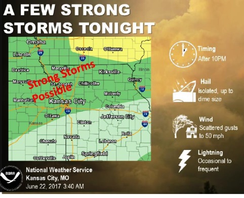
A few strong storms will be possible tonight in Wyandotte County and the surrounding area, according to the National Weather Service.
The storms are most likely to be north of I-70, according to the weather service. The main threats will be small hail and gusty winds.
Today, the high will be near 90 with mostly sunny skies and a heat index as high as 96, the weather service said. There will be a south wind of 7 to 10 mph.
Tonight, there will be a 40 percent chance of showers and thunderstorms after 1 a.m., according to the weather service. The low will be around 68 with a south wind of 6 to 9 mph becoming north after midnight.
Friday, the high will be near 81 with partly sunny skies and a north wind of 8 to 11 mph, the weather service said.
Friday night, it will be mostly clear with a low of 59 and a north northwest wind of 5 to 9 mph, according to the weather service.
Saturday, it will be mostly sunny, with a high near 80, the weather service said. There will be a north northwest wind of 3 to 8 mph.
Saturday night, expect partly cloudy skies and a low of 58, according to the weather service.
Sunday, it will be mostly sunny with a high near 78, the weather service said.
Sunday night, there is a 30 percent chance of showers and thunderstorms after 1 a.m., with a low of 57, according to the weather service.
Monday, it will be mostly sunny with a high near 79, the weather service said.
Monday night, expect partly cloudy skies with a low of 60, according to the weather service.
Tuesday’s forecast is mostly sunny with a high near 82, the weather service said.
Tuesday night, there is a 40 percent chance of showers and thunderstorms, with a low of 66, according to the weather service.