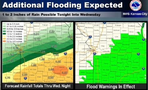
The weather service said that because of the additional rainfall, 1 to 2 inches in places, it may lead to more flooding along area rivers, creeks and streams.
In Wyandotte County, today’s forecast is a high of 67, with a northwest wind of 6 to 10 mph. It will become increasingly cloudy today, the weather service said.
Tonight, there is a 40 percent chance of showers, mainly after 1 a.m., with a low of 49, according to the weather service. A light and variable wind will become east northeast 5 to 7 mph after midnight. Less than a tenth of an inch of rain is expected.
Wednesday, there is a 60 percent chance of showers likely, mainly before 1 p.m., the weather service said. It will be cloudy, with a high near 56, and east wind of 6 to 10 mph. New precipitation amounts of a quarter and half of an inch are possible.
Wednesday night, expect a 20 percent chance of showers before 1 a.m., with a low of 43, according to the weather service. There will be a north northeast wind of 6 to 9 mph.
Thursday, the forecast will be a high near 65 with mostly sunny skies, the weather service said. The wind will be from the north at 6 to 16 mph, gusting up to 28 mph.
Thursday night, expect a low of 47, according to the weather service.
Thursday, it will be sunny with a high near 68, the weather service said.
Friday’s forecast is sunny and a high of 68, the weather service said.
Friday night, expect a low of 47 and mostly clear skies, according to the weather service.
Saturday, it will be sunny with a high near 74, the weather service said.
Saturday night, the low will be around 52 with mostly clear skies, according to the weather service.