A wet and unsettled work week is in store for much of the region as several weather systems are expected to arrive in the area, the National Weather Service said.
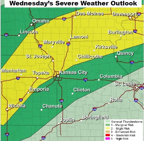
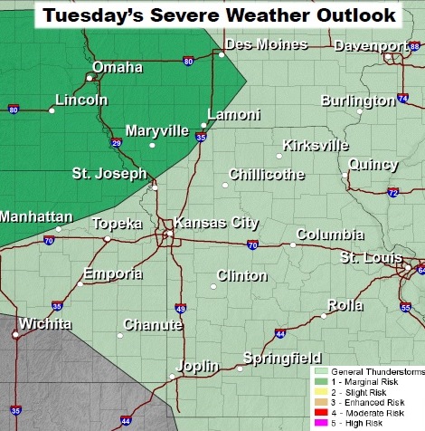
Marginally severe storms will be possible across far northwest Missouri and northeast Kansas on Tuesday and Tuesday night, with more widespread severe weather possible on Wednesday, according to the weather service.
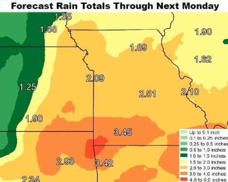
In addition, locally heavy rain also will be possible through the week that may lead to localized flooding of some rivers and streams, the weather service said.
More widespread and severe weather will be possible on Wednesday as storms form over north central Missouri and northeast Kansas during the afternoon and evening hours, according to the weather service. Isolated tornadoes, large hail and damaging wind gusts will be possible with any severe storms that form.
Today, the high will be near 73 with partly sunny skies and an east wind of 7 to 9 mph, the weather service said.
Tonight, look for partly cloudy skies, a low of 55 and an east wind of 6 to 8 mph, according to the weather service.
Tuesday, it will be mostly cloudy with a high near 79, and a south southwest wind of 7 to 11 mph, the weather service said.
Tuesday night, there will be a low of 64 with a 30 percent chance of showers and storms after 8 p.m., according to the weather service. Less than a tenth of an inch of rain is expected.
Wednesday, there is a 30 percent chance of showers and storms before 8 a.m., with a high of 82, the weather service said.
Wednesday night, there is a 40 percent chance of showers and storms, mainly between 8 p.m. and 2 a.m., according to the weather service. The low will be around 52.
Thursday, expect partly sunny skies with a high near 65, the weather service said.