With recent rains, minor river flooding is occurring in the region, but it should improve over the next few days with dry conditions expected, according to the National Weather Service.
Storms are expected to return to the area late Sunday into Sunday night, the weather service said.
There is the potential for these storms to become severe if they do develop, according to the weather service.
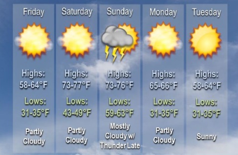
Today, it will be sunny with a high near 64, the weather service said. A calm wind will become south 5 to 8 mph in the morning.
Tonight, expect partly cloudy skies with a low of 50, according to the weather service, and a south wind of 8 to 13 mph.
Saturday, it will be sunny with a high near 77, and a south wind of 11 to 15 mph, gusting to 26 mph, the weather service said.
Saturday night, there will be partly cloudy skies with a low of 64, according to the weather service. A south wind of 11 to 14 mph will gust as high as 28 mph.
Sunday, there will be a 20 percent chance of showers and storms after 1 p.m., with a high near 76, the weather service said. A south southwest wind of 14 to 17 mph will gust as high as 33 mph.
Sunday night, there is a 30 percent chance of showers and thunderstorms, mainly before 1 a.m., according to the weather service. The low will be around 51.
Monday, it will be mostly sunny, with a high near 67, the weather service said.