With recent rains, minor river flooding is occurring in parts of the region, but it should improve during the next few days with dry conditions expected, according to the National Weather Service.
Clear skies and light winds tonight will lead to temperatures falling into the lower 30s on Friday morning, with frost possible. Precautions should be taken to protect sensitive vegetation and avoid damage, the weather service said.
Storms are expected to return to the area Sunday and Sunday night, according to the weather service. There is the potential for these storms to be severe.
The weather service advised drivers who encounter water over the roadways not to try to drive through it.
The frost advisory will be in effect from 1 a.m. April 7 through 9 a.m. April 7, the weather service said. A temperature from 30 to 34 degrees is possible.
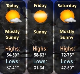
Today’s forecast is sunny with a high near 57, and a north northwest wind of 8 to 13 mph, according to the weather service.
Tonight, it will be clear with a low of 34, and a north northwest wind of 3 to 8 mph, the weather service said.
Friday, expect sunny skies and a high of 63, with a calm wind becoming south 5 to 8 mph in the afternoon, according to the weather service.
Friday night, it will be mostly clear with a low of 50, and a south wind of 8 to 11 mph, the weather service said.
Saturday, it will be sunny with a high near 76, and a south wind of 14 to 16 mph, gusting as high as 24 mph, according to the weather service.
Saturday night, the low will be around 63 with partly cloudy skies, the weather service said.
Sunday, it will be partly sunny with a high of 76.