Goodbye spring-like temperatures, snow is in the forecast tonight through Saturday afternoon.
The National Weather Service says accumulating snow is likely after 3 a.m. and especially after 6 a.m. Saturday across the area.
It should taper off during Saturday afternoon, the weather service said.
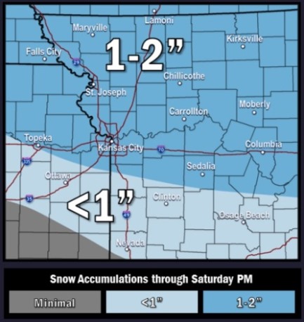
Snowfall accumulations will range from nearly 2 inches along the Iowa border to around an inch or so in the Kansas City area, and could total less than an inch further south, according to the weather service.
Initially, snow accumulations may occur only on elevated or grassy surfaces, but slick roads are possible as snow rates increase during the morning, the weather service said.
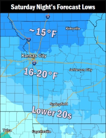
Temperatures will fall into the upper 20s across portions of norther and central portions of the two-state area today, then will drop dramatically into the teens to low 20s area-wide on Saturday night, resulting in a hard freeze for the entire outlook area, according to the weather service.
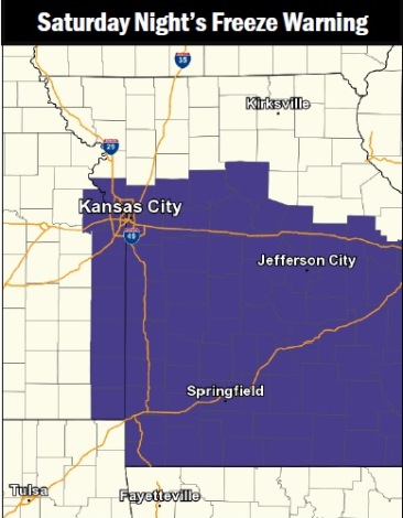
A freeze warning has been issued for Wyandotte County from 6 p.m. March 11 through 1 p.m. March 12, the weather service said.
These conditions will kill crops and other sensitive vegetation, according to the weather service.
Today, there will be a high near 43 with increasing clouds and an east northeast wind of 7 to 11 mph, according to the weather service.
Tonight, there is a 20 percent chance of snow after 3 a.m., according to the weather service. The low will be around 29, with an east northeast wind of 7 to 10 mph.
Saturday, expect an 80 percent chance of snow before 3 p.m., then rain is likely, possibly mixed with snow, the weather service said. The high will be near 35 with an east wind of 7 to 10 mph. From 1 to 2 inches of snow will be possible.
Saturday night, it will be cloudy, with a low of 21, according to the weather service. A northeast wind of 5 to 7 mph will become calm in the evening.
Sunday, the high will be near 41 with partly sunny skies, the weather service said. A light east southeast wind will become south southeast 5 to 10 mph in the morning.
Sunday night, there is a 50 percent chance of rain and snow before 11 p.m., then a chance of rain between 11 p.m. and 5 a.m., then a chance of rain and snow after 5 a.m., the weather service said. The low will be around 33. Less than a tenth of an inch of precipitation is likely.
Monday, there will be a high near 40 with mostly cloudy skies, according to the weather service.
Monday night, there is a 30 percent chance of snow after midnight, with a low of 22, according to the weather service.
Tuesday, the high will be near 39 with mostly sunny skies, the weather service said. Tuesday night’s low will be around 25.