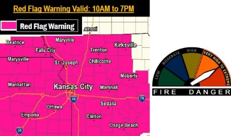
A red flag warning is in effect from 10 a.m. to 7 p.m. on Saturday, March 4, according to the National Weather Service.
Burning is highly discouraged today with the high wildfire danger, the weather service said.
Temperatures will be warm with dry fuels, and relative humidity values dipping into the mid-20s, the weather service said.
Southwesterly winds will be between 20 to 25 mph with gusts exceeding 30 mph at times, according to the weather service.
The next chance for precipitation and thunderstorms holds off until Monday morning into Tuesday morning, the weather service said.
Today’s high will be near 69, with sunny skies, according to the weather service. A south southwest wind of 11 to 20 mph may gust as high as 32 mph.
Tonight, the low will be around 52, with a south wind of 14 to 16 mph, gusting as high as 24 mph, the weather service said.
Sunday, it will be mostly cloudy, with a high near 64, according to the weather service. A south wind of 13 to 21 mph will gust as high as 30 mph.
Sunday night, there will be a 20 percent chance of showers after midnight, the weather service said. The low will be around 56, with a south wind of 16 to 20 mph, gusting as high as 33 mph.
Monday, there will be a 40 percent chance of showers, with thunderstorms also possible, after 1 p.m., according to the weather service. A south southwest wind of 17 to 21 mph will gust as high as 37 mph.
Monday night, expect a 50 percent chance of showers and thunderstorms, the weather service said. The low will be around 39.
Tuesday, it will be sunny with a high near 61, according to the weather service.