
Patchy dense fog greeted motorists this morning in Wyandotte County.
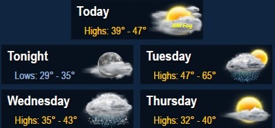
The National Weather Service said there will be patchy fog before 10 a.m. Monday, then cloudy weather will gradually clear with a high near 46 today.
A calm wind will become southeast around 5 p.m. Monday afternoon, the weather service said.
Motorists are advised to use caution this morning, according to the weather service.
Tonight, it will be partly cloudy with a low of 35, the weather service said, and an east southeast wind of 5 to 10 mph.
Tuesday, there will be a slight chance of showers after noon, with a high near 61, according to the weather service. Winds could gust as high as 26 mph with a 20 percent chance of precipitation.
Tuesday night, the low will be around 34 with a west southwest wind of 14 to 16 mph, gusting to 24 mph, the weather service said.
Wednesday, there will be a 20 percent chance of rain and snow, mainly between 10 a.m. and noon, according to the weather service. The high will be near 40. A west northwest wind of 13 to 15 mph will gust as high as 25 mph.
Wednesday night, it will be mostly cloudy with a low of 25, the weather service said.
Thursday, expect sunny skies and a high near 38, according to the weather service. Thursday night, the low will be around 23.
Friday, it will be sunny with a high of 39, the weather service said. Friday night, the low will be around 23.
Saturday’s weather will be mostly sunny with a high of 40, according to the weather service.