A little ice glaze covers streets and sidewalks in Wyandotte County after freezing rain fell Friday night and early Saturday morning. Several accidents were reported.
The ice makes travel uncertain or difficult on Saturday, although Saturday will remain mostly dry, according to the National Weather Service. Periods of freezing drizzle are possible throughout the day, the weather service said. Temperatures were 28 degrees at 9 a.m. Saturday, and may rise to 33 degrees today, according to the weather service.
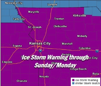
The second round of the ice storm is expected to hit late Saturday night. Wyandotte County remains under an ice storm warning until midnight Sunday night, the weather service said.
Even with just a small amount of ice, residents are being encouraged to stay home, according to the weather service, with travel dangerous in places. While the highways are mostly clear, there could be slick spots in places.
The Board of Public Utilities’ power outage map showed no power outages in Wyandotte County as of 8:30 a.m. Saturday.
The Kansas City, Kan., Public Library will open an hour later on Saturday, at 10 a.m., because of inclement weather.
RideKC, the bus service for the Kansas City area, is encouraging people to stay home, according to a news release. Bus schedules may have changed because of the weather, there may be reduced service, and customers may call 816-221-0660 for more information through noon Saturday, visit www.RideKC.org or www.twitter.com/RideKCTransit and www.facebook.com/RideKCTransit.
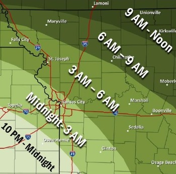
Late tonight, an ice storm is expected to approach the area from southwest to northeast, with the best icing potential beginning during the overnight periods through Sunday afternoon, according to the weather service.
Expected ice totals are trending downward, although hazardous roadways and possible power outages remain a possibility through Sunday afternoon, the weather service said.
Precipitation chances Saturday evening will approach from the southwest and gradually lift northeastward, according to the weather service.
Freezing rain will lead to rapid ice accumulations through Saturday night, making for treacherous travel conditions through a prolonged period, with possible isolated power outages, the weather service said.
Freezing rain will eventually transition to rain by Sunday afternoon, as surface temperatures warm above freezing from south to north, according to the weather service.
Temperatures north of Highway 36, which runs through St. Joseph, Mo., may remain below freezing through all of Sunday, with resulting increased ice accumulations possible through Monday morning, the weather service said.
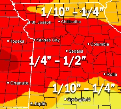
The weather service said total ice accumulations of one-tenth of an inch to one-half of an inch are possible with this storm.
![]()