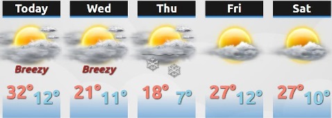
Temperatures will fall today, according to the National Weather Service. The cooler temperatures will stay through the weekend.
Morning wind chill values will be between 5 below and 5 above through Saturday, the weather service said. Light snow is likely in the region from late Wednesday night into Thursday morning, according to the weather service.
Light accumulations of around an inch of snow are possible, the weather service said.
Today will change from cloudy to mostly sunny, with the high about 34, the weather service said. A north northwest wind of 10 to 15 mph will gust as high as 23 mph.
Tonight, expect a low of 13, with a north northwest wind of 9 to 14 mph, gusting as high as 24 mph, according to the weather service.
Wednesday, it will be mostly sunny with a high near 24, and a north northwest wind of around 6 to 8 mph, the weather service said.
Wednesday night, there is a 50 percent chance of snow, mainly after midnight, according to the weather service. The low will be around 12, with a north northwest wind of around 7 mph.
Thursday, there is a 20 percent chance of snow before noon, the weather service said. It will be mostly sunny with a high near 21. Thursday night, it will be partly cloudy with a low of 9, according to the weather service.
Friday, the high will be near 26 with mostly sunny skies, the weather service said. Friday night, the low will be around 13 with partly cloudy skies.
Saturday, it will be mostly sunny with a high near 28, according to the weather service. Saturday night, it will be partly cloudy with a low of 12, according to the weather service.