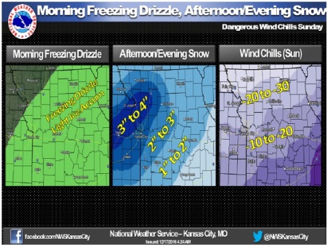
Freezing drizzle will affect the area through late morning leading to light ice accumulations and hazardous driving conditions, according to the National Weather Service.
With ice, snow and dangerously cold temperatures in the forecast, it may be best for residents to stay in a warm place rather than going out today and tonight.
Snow is expected to move into northeastern Kansas and northwestern Missouri late this morning and then slowly spread southeastward across the entire forecast area.
The heaviest accumulations are expected in the northern Kansas City metro area where 3 to 4 inches are possible, the weather service said. The rest of the forecast area will receive 1 to 3 inches.
Dangerous cold is expected by Sunday morning with lows ranging from zero to 10 below zero with wind chill values ranging from 15 to 25 below zero.
Wyandotte County is under a winter weather advisory until 9 p.m. Saturday, Dec. 17. It is also under a wind chill advisory from 9 p.m. Saturday, Dec. 17, until noon Dec. 18.
Today in Wyandotte County there is a slight chance of freezing drizzle before 9 a.m., then snow possible. The snow could be heavy at times, the weather service said. There could be areas of blowing snow after noon.
Temperatures will fall to around 12 by 4 p.m., and wind chill values will be between minus 6 and minus 4. It will be blustery with a north wind of 17 to 20 mph, gusting as high as 28 mph. Total daytime snow accumulation is estimated at 2 to 4 inches possible.
Tonight, there is a 100 percent chance of snow, mainly before midnight, the weather service said. The low will be around minus 5. The wind chill value will be between minus 10 and minus 20. It will be blustery, with a north northwest wind of 10 to 20 mph, with gusts as high as 28 mph. New snow accumulation of less than a half-inch is possible.
Sunday, it will be sunny and cold, with a high near 10, according to the weather service. Wind chill values will be between minus 10 and minus 20. A north northwest wind of 5 to 9 mph will become light and variable in the afternoon.
Sunday night, it will be clear with a low around 2, the weather service said. The wind chill will be between minus 4 and minus 9, and a south southwest wind will be 3 to 6 mph.
Monday, skies will be sunny with a high of 30, and a south southwest wind of 6 to 10 mph, according to the weather service. Monday night, it will be clear with a low of 16.