A big cooldown is expected late next week, as Canadian high pressure will settle south across the Great Plains and Midwest, according to the National Weather Service.
This weekend, a weak storm system may bring light rain and maybe a few snowflakes to the area on Saturday night, the weather service said. There will be no snow accumulation.
The big cooldown late next week is not expected to include any hazardous weather, at this time, the weather service added.
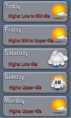
Today’s forecast is sunny with a high of 44, according to the weather service, and a west northwest wind of 5 to 9 mph becoming light west in the afternoon.
Tonight, it will be mostly clear, with a low of 28, the weather service said, and a light and variable wind.
Friday, it will be mostly sunny with a high near 47, according to the weather service, and a light north wind.
Friday night, expect mostly cloudy skies with a low of 30, the weather service said, and a light north northeast wind.
Saturday, it will be mostly cloudy with a high near 43, according to the weather service, and a calm wind becoming east southeast around 5 mph.
Saturday night, there is a 40 percent chance of rain, according to the weather service. The low will be 36. New precipitation amounts of less than a tenth of an inch are possible.
Sunday, it will be mostly sunny with a high near 49, the weather service said.
Sunday night, the low will be 33 with mostly clear skies, according to the weather service.
Monday, it will be partly sunny with a high near 67, the weather service said.
Monday night, there is a 30 percent chance of rain, with a low of 38, according to the weather service.
Tuesday’s high will be near 50, and Tuesday night’s low will be around 36, according to the weather service.
Wednesday, there is a 40 percent chance of rain and snow, with a high near 40, the weather service said.